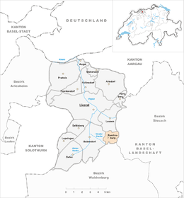
Ramlinsburg
| Ramlinsburg | ||
|---|---|---|
|
||
| Coordinates: 47°27′N 7°46′E / 47.450°N 7.767°ECoordinates: 47°27′N 7°46′E / 47.450°N 7.767°E | ||
| Country | Switzerland | |
| Canton | Basel-Landschaft | |
| District | Liestal | |
| Area | ||
| • Total | 2.24 km2 (0.86 sq mi) | |
| Elevation | 494 m (1,621 ft) | |
| Population (Mar 2016) | ||
| • Total | 693 | |
| • Density | 310/km2 (800/sq mi) | |
| Postal code | 4433 | |
| SFOS number | 2832 | |
| Surrounded by | Bubendorf, Hölstein, Itingen, Lausen, Zunzgen | |
| Website |
www SFSO statistics |
|
Ramlinsburg is a municipality in the district of Liestal in the canton of Basel-Country in Switzerland.
Ramlinsburg is first mentioned in 1367 as Remlisperg. It was located near the Bubendorf courthouse and belonged to the Salland.
In the 15th century, Henman Sevogel, Lord of the Castle Wildenstein (located between Bubendorf and Ziefen), was the owner of the Salland region. He passed the ownership of Ramlinsburg to the Basel Bishops.
For many years, the town consisted of just two independent farms, Ober- (upper) and Niederramlisberg (lower Ramlisberg). Today, these are called Oberhof and Niderhof. In the 16th century, a town began to develop around these two farms.
The two regions remained independent until 1926, when they were merged to create the community of Ramlinsburg.
Ramlinsburg has an area, as of 2009[update], of 2.24 square kilometers (0.86 sq mi). Of this area, 0.91 km2 (0.35 sq mi) or 40.6% is used for agricultural purposes, while 1.05 km2 (0.41 sq mi) or 46.9% is forested. Of the rest of the land, 0.29 km2 (0.11 sq mi) or 12.9% is settled (buildings or roads).
Of the built up area, housing and buildings made up 10.7% and transportation infrastructure made up 2.2%. Out of the forested land, 45.1% of the total land area is heavily forested and 1.8% is covered with orchards or small clusters of trees. Of the agricultural land, 8.0% is used for growing crops and 27.7% is pastures, while 4.9% is used for orchards or vine crops.
The municipality is located in the Liestal district, in the north-east portion of the Vorderen Frenke valley.
The blazon of the municipal coat of arms is Or, bordered Gules, two Crescents edorsed Azure.
Ramlinsburg has a population (as of March 2016[update]) of 693. As of 2008[update], 12.2% of the population are resident foreign nationals. Over the last 10 years (1997–2007) the population has changed at a rate of 36.1%.
...
Wikipedia


