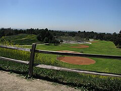
Ralph B. Clark Regional Park
| Ralph B. Clark Regional Park | |
|---|---|

View of the park from Camel Hill
|
|
| Type | Regional (Orange County, California) |
| Location | 8800 Rosecrans Ave. Buena Park, California (714) 973-3170 |
| Coordinates | 33°53′35″N 117°58′45″W / 33.89306°N 117.97917°WCoordinates: 33°53′35″N 117°58′45″W / 33.89306°N 117.97917°W |
| Area | 105 acres (42 ha) |
| Created | 1981 |
| Status | Open |
Ralph B. Clark Regional Park is an urban park located primarily in Buena Park, California south of Rosecrans Avenue at the southern edge of the West Coyote Hills. A smaller section with six softball fields is located north of Rosecrans Avenue in Fullerton, California. The park was originally opened as Los Coyotes Regional Park in 1981, and was renamed in 1987 after then-retiring Orange County Supervisor Ralph B. Clark (1917–2009).
Amphitheater, barbecues, baseball/softball fields, bicycling, fire rings, fishing, group picnic areas, hiking trails, horseshoe pits, Interpretive Center, interpretive programs, model sail boating, picnic tables, picnic shelters, playground equipment, tennis courts, volleyball courts.
The Interpretive Center is a small museum which features ice age fossil and local geology exhibits.
The Center has an impressive mural of ice age mammals by Mark Hallet.
Among the fossils on display is a 9-million-year-old baleen whale skeleton that was recovered from a local construction site. It is reputed to be one of the only complete Miocene whale fossils in existence.
Admission is free.
The park has a pleasant tree shaded trail that runs about 1.2 miles (1.9 km) along its periphery (including a 0.3-mile (500 m) walk along the north edge of the park).
The trail rises to the top of Camel Hill (located in the north east corner of the park). Sights from the top of Camel Hill include Catalina Island, the Long Beach port, Signal Hill, Palos Verdes Peninsula, the KFI radio tower, Hawks Point Bluff, Mount Baldy, the Los Coyotes Country Club, the Santa Ana Mountains and the Huntington Beach Power Plant structures.
Nearby Trails
The trail head for the Emery Ranch Trail lies just to the west of the portion of the park which is north of Rosecrans Avenue. This is a somewhat steep 0.4-mile (600 m) long trail that winds its way up through the local coastal sage scrub plant community. The trail ends at the peak of the hill near a water storage tank.
...
Wikipedia
