Radstädter Tauern
| Radstadt Tauern | |
|---|---|

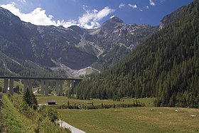
Tauern Autobahn near Flachau
|
|
| Highest point | |
| Peak | Weißeck |
| Elevation | 2,711 m (8,894 ft) |
| Coordinates | 47°09′46″N 13°23′38″E / 47.16278°N 13.39389°E |
| Geography | |
| Country | Austria |
| State | Salzburg |
| Range coordinates | 47°09′00″N 13°23′00″E / 47.15000°N 13.38333°ECoordinates: 47°09′00″N 13°23′00″E / 47.15000°N 13.38333°E |
| Parent range |
Central Eastern Alps Low Tauern |
The Radstadt Tauern (German: Radstädter Tauern) are a subrange of the Central Eastern Alps in Austria. Together with the Schladming Tauern, the Rottenmann and Wölz Tauern and the Seckau Tauern the Radstadt Tauern form the major range of mountains known as the Low Tauern. The mountains are found in the southeast of the Austrian state of Salzburg, between the upper reaches of the Enns and Mur rivers.
The Radstadt Tauern form the westernmost part of the Low Tauern range. They are bounded to the southwest by the High Tauern, to the northwest by the Salzburg Pongau region, and to the east by the Schladming Tauern. Their name is derived from the historic town of Radstadt in the Enns valley.
The Radstadt Tauern border on the following other mountain ranges of the Alps:
According to the Alpine Club classification of the Eastern Alps (AVE), the mountains are bounded by the following line, in a clockwise direction: Wagrainer Bach from its confluence with the Salzach – Wagrainer Höhe – Litzlingbach to its confluence with the Enns – Enns to Radstadt – Northern Taurach valley – Obertauern – Southern Taurach valley – Mauterndorf – Neuseß – Mur – Murtörl Pass – Kreealpenbach – Großarlbach to its confluence with the Salzach – Salzach to its confluence with the Wagrainer Bach.
...
Wikipedia

