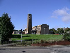
Radford, Coventry
| Radford | |
|---|---|
 St. Nicholas Church, Radford |
|
| Radford shown within the West Midlands | |
| Population | 18,879 (2011.Ward) |
| • Density | 64.7 per ha |
| Metropolitan borough | |
| Metropolitan county | |
| Region | |
| Country | England |
| Sovereign state | United Kingdom |
| Post town | COVENTRY |
| Postcode district | CV6 |
| Dialling code | 024 |
| Police | West Midlands |
| Fire | West Midlands |
| Ambulance | West Midlands |
| EU Parliament | West Midlands |
| UK Parliament | |
Radford is a suburb and electoral ward of Coventry, located approximately 2 miles north of Coventry city centre. It is covered by the Coventry North West constituency.
Radford ward is bounded by Holbrooks, Foleshill, St Michael's, Sherbourne, and Bablake wards. It is covered by the North East Neighbourhood Management area. It covers an area of 303.9 hectares.
Radford consists of four neighbourhoods; Radford Diamond, East Radford, West Radford, and Canal Basin. Radford Diamond is located approximately one mile to the northwest of Coventry city centre and is bounded by Barkers Butts Lane, Lawrence Saunders Road and the Radford Road with the Coventry-Nuneaton railway forming the southern boundary. East Radford is a small neighbourhood consisting of six streets of densely populated housing: Newfield Road, Dorset Road, Somerset Road, Widdrington Road, Kingfield Road and Aldbourne Road. The Coventry-Nuneaton railway bounds the area on one side whilst the Coventry Canal bounds the other. West Radford is a large neighbourhood with a population of approximately 3,800, located approximately two miles north of the city centre. The Jubilee Crescent area, the area around St. Augustine's School and the Beake Avenue/Radford Road area are the three distinct parts to the neighbourhood. The Canal Basin neighbourhood comprises Leicester Row, St Nicholas Street, St Columba's Close and the Draper's Field development.
At the end of the 19th century, Radford was turning from a largely undeveloped rural area into one of Coventry's major manufacturing areas. The southern area of Radford benefited from the presence of the Coventry Canal and also the railway, and was served by Daimler Halt railway station, located on Sandy Lane. This was also the site of the Sandy Lane power station, which has now been turned into a mixed use residential and business development - Electric Wharf.
Possibly Radford's greatest historical claim to fame comes from its centrality in the birth of the British motor car industry. The Great Horseless Carriage Company was established in 1896 in converted cotton mill works, and renamed Motor Mills, between St. Nicholas Street, Sandy Lane, and the Coventry Canal. It included a red-brick office block with stone banding on Sandy Lane built 1907-08, and an electricity power house which was added in 1907. Soon after, the company changed its name to Daimler and shortly before the First World War, they moved to a new factory at the Lydgate Road/Sandy Lane Junction. The factory was greatly extended during and after the First World War to incorporate entrances on both Sandy Lane and Middlemarch Road. After a merger in 1960, the factory also became home to Jaguar, who remained there till production ceased in the mid-1990s.
...
Wikipedia

