RAF Stradishall
|
RAF Stradishall |
|||||||||||||||||||
|---|---|---|---|---|---|---|---|---|---|---|---|---|---|---|---|---|---|---|---|

Latin: Vires de caelo
("Might from the sky") |
|||||||||||||||||||

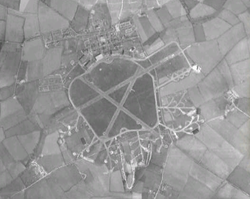
Aerial view in 1945
|
|||||||||||||||||||
| Summary | |||||||||||||||||||
| Airport type | Military | ||||||||||||||||||
| Owner | Ministry of Defence | ||||||||||||||||||
| Operator | Royal Air Force | ||||||||||||||||||
| Location | Stradishall, Suffolk | ||||||||||||||||||
| Built | 1937 | ||||||||||||||||||
| In use | 1938-1970 | ||||||||||||||||||
| Elevation AMSL | 381 ft / 116 m | ||||||||||||||||||
| Coordinates | 52°08′06″N 000°30′51″E / 52.13500°N 0.51417°ECoordinates: 52°08′06″N 000°30′51″E / 52.13500°N 0.51417°E | ||||||||||||||||||
| Map | |||||||||||||||||||
| Location in Suffolk | |||||||||||||||||||
| Runways | |||||||||||||||||||
|
|||||||||||||||||||
Royal Air Force Stradishall or more simply RAF Stradishall is a former Royal Air Force station located 4.7 miles (7.6 km) north east of Haverhill, Suffolk and 9 miles (14 km) south west of Bury St Edmunds, Suffolk, England.
The airfield was home to a number of squadrons during its lifetime:
The airfield closed in 1970 and is now the site of two category C prisons: HMP Highpoint North and HMP Highpoint South. Part of the former airfield remains a Ministry of Defence training site which is not accessible to the public.
The airfield has been sold to a private buyer to be converted into farm land and is out of bounds to the public.
There is a memorial to RAF Stradishall outside Stirling House which was once part of the officers quarters and is now a training unit for the Prison service.
...
Wikipedia

