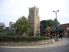
Haverhill, Suffolk
| Haverhill | |
|---|---|
 Market Hill and parish church, Haverhill |
|
| Haverhill shown within Suffolk | |
| Population | 27,041 (2011 Census) |
| OS grid reference | TL671456 |
| • London | 47 miles (76 km) |
| District | |
| Shire county | |
| Region | |
| Country | England |
| Sovereign state | United Kingdom |
| Post town | HAVERHILL |
| Postcode district | CB9 |
| Dialling code | 01440 |
| Police | Suffolk |
| Fire | Suffolk |
| Ambulance | East of England |
| EU Parliament | East of England |
| UK Parliament | |
Haverhill (pronounced /ˈheɪvəhɪl/ or /ˈheɪvrɪl/) is a market town and civil parish in the county of Suffolk, England, next to the borders of Essex and Cambridgeshire. It lies 14 miles (23 km) southeast of Cambridge and 47 miles (76 km) north-east of central London. Haverhill is the second largest town in the Borough of St Edmundsbury and has a population of 27,041
The town centre lies at the base of a gentle dip in the chalk hills of the Newmarket Ridge; running through the town is the Stour Brook, which goes on to join the River Stour just outside the town. Rapid expansion of the town over the last two decades means that the western edge of Haverhill now includes the hamlet of Hanchet End. The surrounding countryside largely consists of arable land.
Haverhill dates back to at least Saxon times, and the town's market is recorded in the Domesday book (1086). Whilst most of its historical buildings were lost to the great fire on 14 June 1667, one notable Tudor-era house remains (reportedly given to Anne of Cleves as part of her divorce from Henry VIII and thus titled Anne of Cleves House) as well as many interesting Victorian buildings.
...
Wikipedia

