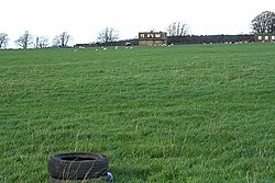
RAF Culmhead
| RAF Culmhead | |||||||||||
|---|---|---|---|---|---|---|---|---|---|---|---|
| Churchstanton, Somerset in England | |||||||||||

The old control tower taken in 2006
|
|||||||||||
|
Shown within Somerset
|
|||||||||||
| Coordinates | 50°55′46″N 003°07′42″W / 50.92944°N 3.12833°WCoordinates: 50°55′46″N 003°07′42″W / 50.92944°N 3.12833°W | ||||||||||
| Type | Royal Air Force station | ||||||||||
| Site information | |||||||||||
| Owner | Air Ministry | ||||||||||
| Operator |
Royal Air Force Royal Navy |
||||||||||
| Site history | |||||||||||
| Built | 1941 | ||||||||||
| In use | 1941–1946 | ||||||||||
| Airfield information | |||||||||||
| Elevation | 264 metres (866 ft) AMSL | ||||||||||
|
|||||||||||
RAF Culmhead is a former Royal Air Force station, situated at Churchstanton on the Blackdown Hills in Somerset, England.
It had three tarmac runways that are now in poor condition and the control towers are currently derelict. There is now an industrial estate – derived from the later Composite Signals Organisation Station (CSOS) – right in the middle of the place where the three runways meet.
RAF Culmhead was a typical three-runway fighter airfield, with blast pens built around the site along with ten blister hangars. It was used by fighters from RAF Exeter from June but officially opened on 1 August 1941. Ground defence was provided by the Somerset Light Infantry.
The airfield was occupied by No. 2 Polish Wing of the Polish Air Force. The first squadrons to arrive were No. 316 (Warsaw) and No. 302 (Poznań) equipped with Hawker Hurricane Mk.Is. No. 302 soon left to be replaced with No. 306 (Torun) who operated Spitfires. In the summer of 1942 the polish squadrons were replaced by No. 313 and No. 312 Squadrons which were Czechoslovakian-manned. The site was also used for the testing of barrage balloon wire cutters in 1942 by 02 Detachment of the Royal Aircraft Establishment from Farnborough.
...
Wikipedia

