Blackdown Hills
| Blackdown Hills | |
| Area of Outstanding Natural Beauty | |
|
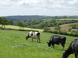
Blackdown Hills AONB near Dalwood, Devon
|
|
| Country | England |
|---|---|
| Counties | Devon Somerset |
| Location | south-west England |
| - coordinates | 50°56′49″N 3°13′47″W / 50.94694°N 3.22972°WCoordinates: 50°56′49″N 3°13′47″W / 50.94694°N 3.22972°W |
| Highest point | |
| - location | Staple Hill |
| - elevation | 315 m (1,033 ft) |
| - coordinates | 50°56′34″N 3°05′25″W / 50.94278°N 3.09028°W |
| Area | 370 km2 (143 sq mi) |
| Geology | Upper Greensand |
| AONB | 1991 |
| Management | Blackdown Hills AONB |
| - location | St Ivel House, Hemyock, Cullompton, Devon, EX15 3SJ |
| - coordinates | 50°54′52″N 3°13′55″W / 50.91444°N 3.23194°W |
|
Location of the Blackdown Hills AONB in the UK
|
|
The Blackdown Hills are a range of hills along the Somerset-Devon border in south-western England, which were designated an Area of Outstanding Natural Beauty (AONB) in 1991.
The plateau is dominated by hard chert bands of Upper Greensand with some remnants of chalk, and is cut through by river valleys. The hills support an extensive range of wildlife leading to the designation of 16 Sites of Special Scientific Interest (SSSIs).
There is evidence of human occupation since the Iron Age. Fortifications include the remains of ancient hill forts, Norman motte-and-bailey castles and Second World War airfields. There are also religious buildings such as Dunkeswell Abbey and village churches. The hills are crossed by a network of minor roads with major transport routes including the M5 motorway running around the periphery.
The Blackdowns form a natural region that has been designated as a national character area - No. 147 - by Natural England, the public body responsible for England's natural environment. Neighbouring natural regions are: the Devon Redlands to the west, the to the north, the Mid Somerset Hills to the northeast, the Yeovil Scarplands to the east and the to the southeast.
Straddling the borders of Somerset and Devon, the Blackdown Hills AONB covers an area of 370 square kilometres (143 sq mi). Heavily cut with sharp valleys, the hills reach their highest point of 315 metres (1,033 ft) above sea level at Staple Hill in Somerset. The hills in the southern part of the area, near Honiton in Devon, are more gentle. The Blackdown Hills are a sparsely populated area; much of the land is used for dairy farming.
...
Wikipedia


