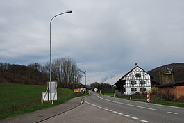
Rümikon
| Rümikon | ||
|---|---|---|
 |
||
|
||
| Coordinates: 47°34′N 8°23′E / 47.567°N 8.383°ECoordinates: 47°34′N 8°23′E / 47.567°N 8.383°E | ||
| Country | Switzerland | |
| Canton | Aargau | |
| District | Zurzach | |
| Area | ||
| • Total | 2.9 km2 (1.1 sq mi) | |
| Elevation | 343 m (1,125 ft) | |
| Population (Dec 2015) | ||
| • Total | 291 | |
| • Density | 100/km2 (260/sq mi) | |
| Postal code | 5464 | |
| SFOS number | 4317 | |
| Surrounded by | Fisibach, Hohentengen am Hochrhein (DE-BW), Mellikon, Wislikofen | |
| Website |
www SFSO statistics |
|
Rümikon is a municipality in the district of Zurzach in the canton of Aargau in Switzerland. Its late Roman watchtower at the Sandgraben is listed as a heritage site of national significance.
Along the river Rhine, in the municipal area, are the remains of two Roman era watchtowers. The community name may come from an earlier, nearby Alamanni settlement. The modern village of Rümikon is first mentioned in 1113 as Ruminchon. The Freiherr von Waldhausen granted the village to the provost of Wislikofen, who ran the low courts. Between 1415 and 1798 the village went to the district of Ehrendingen in County of Baden.
For centuries the most important industry in the village was fishing. In 1440 John Escher mortgaged the farm Rümikon except for the Fischenz or fishery to four brothers from Rümikon. In 2009, the Fischenz was acquired by the local citizen's community.
Rümikon was part of the parish of Schneisingen until 1857, when it joined the Wislikofen parish. The Anna chapel was built in 1710, renovated in 1797 and renovated again in 1973.
In 2000, about 80% of the workers commuted to jobs outside the municipality. In 1876 the joint Mellikon-Rümikon railway station was built on the Koblenz-Winterthur line. Since 1995 this was replaced with a station in the village.
Rümikon has an area, as of 2009[update], of 2.9 square kilometers (1.1 sq mi). Of this area, 1.19 km2 (0.46 sq mi) or 41.0% is used for agricultural purposes, while 1.3 km2 (0.50 sq mi) or 44.8% is forested. Of the rest of the land, 0.25 km2 (0.097 sq mi) or 8.6% is settled (buildings or roads), 0.19 km2 (0.073 sq mi) or 6.6% is either rivers or lakes.
...
Wikipedia


