Rózsahegy
| Ružomberok | ||
| town | ||
|
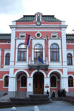
Town hall of Ružomberok
|
||
|
|
||
| Country | Slovakia | |
|---|---|---|
| Region | Žilina | |
| District | Ružomberok | |
| Tourism region | Liptov | |
| River | Váh | |
| Elevation | 494 m (1,621 ft) | |
| Coordinates | 49°04′43″N 19°18′30″E / 49.07861°N 19.30833°ECoordinates: 49°04′43″N 19°18′30″E / 49.07861°N 19.30833°E | |
| Area | 126.72 km2 (49 sq mi) | |
| Population | 29,906 (2006-12-31) | |
| Density | 237/km2 (614/sq mi) | |
| First mentioned | 1233 | |
| Mayor | Igor Čombor | |
| Timezone | CET (UTC+1) | |
| - summer (DST) | CEST (UTC+2) | |
| Postal code | 034 01 | |
| Phone prefix | 421-44 | |
| Car plate | RK | |
| Statistics: MOŠ/MIS | ||
| Website: http://www.ruzomberok.eu/en/ | ||
Ružomberok (Slovak pronunciation: [ˈruʒomberok] (![]() listen); German: Rosenberg; Hungarian: Rózsahegy; Polish: Rużomberk) is a town in northern Slovakia, in the historical Liptov region. It has a population of around 30,000 (45,000 with nearby villages)
listen); German: Rosenberg; Hungarian: Rózsahegy; Polish: Rużomberk) is a town in northern Slovakia, in the historical Liptov region. It has a population of around 30,000 (45,000 with nearby villages)
The name of the initial settlement located on today's Makovický street was Revúca (roaring "roaring", derived from the Revúca river). In its neighborhood, German colonists build a new settlement Rosenberg named after wild roses growing in the area. This name was later adopted by Slovaks as Ružomberok.
It is situated at the westernmost reaches of the Sub-Tatra Basin, more exactly its subdivision Liptov Basin, surrounded by the mountain ranges of Chočské vrchy, Greater Fatra and Low Tatras. Rivers flowing through the town are Váh, from east to west, Revúca, a left tributary from the south, on the way to Banská Bystrica and Likavka brook from the north, on the way to Dolný Kubín. The town is located around 65 km from Žilina, 190 km from Košice and 260 km from Bratislava (by road). Besides the main settlement, it also has "city parts" of Biely Potok, Černová, Hrboltová and Vlkolínec.
...
Wikipedia


