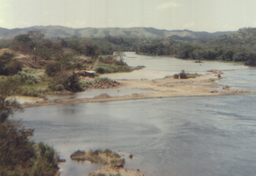
Río Chagres
| Chagres River (Spanish: Río Chagres) | |
|
The Chagres River as seen from the highway between Panama City and Colon
|
|
| Country | Panama |
|---|---|
| Source | |
| - location | Chagres National Park, Panamá Province, Panama |
| - coordinates | 9°24′N 79°17′W / 9.400°N 79.283°W |
| Mouth | |
| - location | Chagres, Colón Province, Panama |
| - coordinates | 9°19′N 80°0′W / 9.317°N 80.000°WCoordinates: 9°19′N 80°0′W / 9.317°N 80.000°W |
| Length | 120 mi (193 km), east to west |
| Basin | 1,259.5 sq mi (3,262 km2) |
The Chagres River (Spanish pronunciation: [ˈtʃaɣɾes]), in central Panama, is the largest river in the Panama Canal's watershed. The river is dammed twice, and the resulting reservoirs—Gatun Lake and Lake Alajuela—form an integral part of the canal and its water system. Although the river's natural course runs northwest into the Caribbean Sea, its waters also flow, via the canal's locks, into the Gulf of Panama to the south, entitling the Chagres to the unusual claim of drainage into two oceans.
The upper Chagres River, its watershed, and the watershed of several tributaries lie within the Chagres National Park, created in 1985 to preserve the flow of water into the canal. The terrain of the upper Chagres watershed is rugged, with its mountain slopes exceeding 45 degrees in 90 percent of its territory. Some 98 percent of the park consists of old-growth tropical forest.
The upper Chagres and its seven tributaries flow into Lake Alajuela (formerly Madden Lake), the reservoir created by the Madden Dam. As these rivers contribute 45 percent of the total water for the canal, the lake is an essential part of the watershed of the canal zone. The lake has a maximum level of 76 metres (250 ft) above sea level, and can store one third of the canal's annual water requirements for the operation of the locks. Unlike Gatun Lake, Lake Alajuela is not part of the navigational route, so there are fewer restrictions on its water level. Water from the reservoir is also used to generate hydroelectric power and to supply Panama City's fresh water.
At 3.2 kilometres (2.0 mi) from the river's mouth lies the Gatun Dam, which created Gatun Lake and provides hydroelectricity. Created in 1913 by the damming of the Chagres River, Gatun Lake is an essential part of the Panama Canal, which forms a water passage between the Atlantic Ocean and the Pacific Ocean, permitting ship transit in both directions. The lake is essential to the canal's water supply, as it provides the millions of gallons of water at the high level needed for the locks to function correctly. The lake is also part of the navigational canal and provides drinking water for Panama City and Colon.
...
Wikipedia

