Quitman, Missouri
| Quitman, Missouri | |
|---|---|
| Unincorporated community | |

Quitman in 2009
|
|
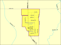
 Location of Quitman, Missouri |
|
 U.S. Census Map |
|
| Coordinates: 40°22′23″N 95°4′37″W / 40.37306°N 95.07694°WCoordinates: 40°22′23″N 95°4′37″W / 40.37306°N 95.07694°W | |
| Country | United States |
| State | Missouri |
| County | Nodaway |
| Area | |
| • Total | 0.13 sq mi (0.34 km2) |
| • Land | 0.13 sq mi (0.34 km2) |
| • Water | 0 sq mi (0 km2) |
| Elevation | 961 ft (293 m) |
| Population (2010) | |
| • Total | 45 |
| • Estimate (2012) | 45 |
| • Density | 350/sq mi (130/km2) |
| Time zone | Central (CST) (UTC-6) |
| • Summer (DST) | CDT (UTC-5) |
| ZIP code | 64478 |
| Area code(s) | 660 |
| FIPS code | 29-60410 |
| GNIS feature ID | 0730184 |
Quitman is an unincorporated community in Nodaway County, Missouri, United States. The population was 45 at the 2010 census.
Originally it was called Russellville which was first platted in 1856 by R. R. Russell. Later, the name was changed to Quitman in honor of John A. Quitman, a former governor of Mississippi and war hero in the Mexican-American War. The city was incorporated on February 8, 1881 when it was a stop on the Nodaway Valley Railroad (which was building the railroad for the Kansas City, St. Joseph and Council Bluffs Railroad that eventually became part of the Burlington Northern network. The railroad no longer continues.
In November 2012, the Nodaway County Commission voted to disincorporate Quitman after local residents asked for it.
Quitman is located at 40°22′23″N 95°4′37″W / 40.37306°N 95.07694°W (40.373105, -95.076915). According to the United States Census Bureau, the city has a total area of 0.13 square miles (0.34 km2), all of it land.
As of the census of 2010, there were 45 people, 23 households, and 11 families residing in the city. The population density was 346.2 inhabitants per square mile (133.7/km2). There were 27 housing units at an average density of 207.7 per square mile (80.2/km2). The racial makeup of the city was 100.0% White.
...
Wikipedia
