Quilpie
|
Quilpie Queensland |
|||||||||||||
|---|---|---|---|---|---|---|---|---|---|---|---|---|---|

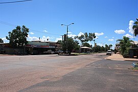
Brolga St, the main street of Quilpie
|
|||||||||||||
| Coordinates | 26°37′S 144°16′E / 26.617°S 144.267°ECoordinates: 26°37′S 144°16′E / 26.617°S 144.267°E | ||||||||||||
| Population | 574 (2011 census) | ||||||||||||
| Established | 1917 | ||||||||||||
| Postcode(s) | 4480 | ||||||||||||
| Location |
|
||||||||||||
| LGA(s) | Shire of Quilpie | ||||||||||||
| State electorate(s) | Gregory | ||||||||||||
| Federal Division(s) | Maranoa | ||||||||||||
|
|||||||||||||
Quilpie (/ˈkwɪlpi/ KWIL-pee) is a town and a locality situated in the Channel Country of South West Queensland, Australia. The town is the administrative centre of the Quilpie Shire local government area. In the 2011 census, Quilpie had a population of 574 people.
The economy of the area is based on the grazing and mining industries. The area has one of the largest deposits of boulder opal in the world, and also has extensive deposits of gas and oil.
Situated on the banks of the Bulloo River and on the Diamantina Developmental Road, it is 208 kilometres (129 mi) west of Charleville, and 980 kilometres (610 mi) west of the state capital, Brisbane. Quilpie is the administrative centre of the Quilpie Shire, which at the 2006 census had a population of 986. Other townships in the shire include Adavale and Eromanga.
In the 2006 census, Quilpie had a population of 560, a decline from the 2001 census population of 645. Around 14% of the population of Quilpie identity as Aboriginal or Torres Strait Islander and around 1% were born outside Australia.
...
Wikipedia

