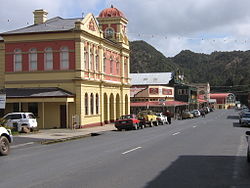
Queenstown, Tasmania
|
Queenstown Tasmania |
|||||||
|---|---|---|---|---|---|---|---|

Orr Street, from centre, looking west
|
|||||||
| Coordinates | 42°04′50″S 145°33′20″E / 42.08056°S 145.55556°ECoordinates: 42°04′50″S 145°33′20″E / 42.08056°S 145.55556°E | ||||||
| Population | 1,975 (2011 census) | ||||||
| Postcode(s) | 7467 | ||||||
| Elevation | 129 m (423 ft) | ||||||
| Location | |||||||
| LGA(s) | West Coast Council | ||||||
| State electorate(s) | Braddon | ||||||
| Federal Division(s) | Braddon | ||||||
|
|||||||
Queenstown is a town in the West Coast region of the island of Tasmania, Australia. It is in a valley on the western slopes of Mount Owen on the West Coast Range.
At the 2011 census, Queenstown had a population of 1,975 people.
Queenstown's history has long been tied to the mining industry. This mountainous area was first explored in 1862. It was long after that when alluvial gold was discovered at Mount Lyell, prompting the formation of the Mount Lyell Gold Mining Company in 1881. In 1892, the mine began searching for copper. The final name of the Mount Lyell company was the Mount Lyell Mining and Railway Company.
Queenstown Post Office opened on 21 November 1896. A Queenstown South office opened in 1949 and closed in 1973.
In the 1900s, Queenstown was the centre of the Mount Lyell mining district and had numerous smelting works, brick-works, and sawmills. The area at the time was finely wooded. The population in 1900 was 5051; the district, 10,451.
The town was the base of the Queenstown council up until amalgamation with other west coast councils in the 1990s. The town in its heyday had a collection of hotels, churches and schools that have all significantly reduced since the demise of the Mount Lyell company.
The town was the base of the Organisation for Tasmanian Development started in 1982.
There was a brief boom in prosperity in the 1980s, with the building of several nearby dams by the Hydro. The Darwin and Crotty dams that comprise Lake Burbury (a popular fishing and recreation venue) were built during this period. These followed the cancellation of the Gordon-below-Franklin Dam in 1983 after strong campaigning by environmentalists in the 'No Dams' campaign.
The mountains surrounding Queenstown have unusual pink and grey hues that come from the conglomerate rocks on the two most adjacent mountains - Mount Lyell and Mount Owen. The mountains surrounding Queenstown are often snowcapped through winter. Snow falls a few days out of the year.
...
Wikipedia

