Queen Anne Hill
| Queen Anne | |
|---|---|
| Seattle Neighborhood | |

Queen Anne Hill as seen from Hamilton Viewpoint
|
|
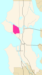
 Map of Queen Anne's location in Seattle |
Queen Anne Hill is an affluent neighborhood and geographic feature in Seattle, northwest of downtown. The neighborhood sits on the highest named hill in the city, with a maximum elevation of 456 feet (139 m). It covers an area of 7.3 square kilometers (2.8 sq mi), and has a population of about 28,000. Queen Anne is bordered by Belltown to the south, Lake Union to the east, the Lake Washington Ship Canal to the north and Interbay to the west.
The hill became a popular spot for the city's early economic and cultural elite to build their mansions, and the name derives from the architectural style typical of many of the early homes.
Queen Anne is bounded on the north by the Fremont Cut of the Lake Washington Ship Canal, beyond which is Fremont; on the west by 15th and Elliott Avenues West, beyond which is Interbay, Magnolia, and Elliott Bay; on the east by Lake Union and Aurora Avenue North, beyond which is Westlake. As a neighborhood toponym, Queen Anne may include Lower Queen Anne, also known as Uptown, the area at the southern base of the hill, just north and west of Seattle Center. Whether or not Lower Queen Anne is considered a separate neighborhood matters in setting Queen Anne's southern boundary, which is either West Mercer Street or Denny Way.
Queen Anne can be reached from Interstate 5 via the Mercer Street Exit (Exit 167). The neighborhood's main thoroughfares are Gilman Drive West, 3rd Avenue West, Queen Anne Avenue North, Boston Street, and a set of streets, collectively known as Queen Anne Boulevard, that loop around the crown of the hill and reflect a comprehensive boulevard design in the style of the Olmsted Brothers architectural firm. The design was never fully executed, but it remains part of the Seattle Parks System.
...
Wikipedia
