Elliott Bay
| Elliott Bay | |
|---|---|

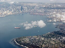
Aerial view of Elliott Bay
|
|
| Coordinates | 47°36′11″N 122°22′23″W / 47.603°N 122.373°WCoordinates: 47°36′11″N 122°22′23″W / 47.603°N 122.373°W |
| River sources | Duwamish River |
| Ocean/sea sources | Puget Sound |
| Basin countries | United States |
| Surface area | 21 km2 (8.1 sq mi) |
| Settlements | Seattle |
| References | |
Elliott Bay is a part of the Central Basin region of Puget Sound in the U.S. state of Washington that extends southeastward between West Point in the north and Alki Point in the south. Seattle was founded on this body of water in the 1850s and has since grown to encompass it completely. The waterway it provides to the Pacific Ocean has served as a key element of the city's economy, enabling the Port of Seattle to become one of the busiest ports in the United States.
The bay was named during the Wilkes expedition in 1841, however it is not known for whom the bay is named. Candidates include members of the expedition: Jared Elliott, ship's chaplain; George Elliott, ship's boy; and Midshipman Samuel Elliott. The last has been deemed the most likely namesake. Commodore Jesse Elliott has also been proposed as a possible source of the name. The bay has been referred to as Duwamish Bay and Seattle Harbor, especially before the US Board on Geographic Names officially settled on the name "Elliott Bay" in 1895.
The Duwamish people lived in the vicinity of Elliott Bay and the Duwamish River for thousands of years and had established at least 17 settlements by the time white settlers came in the 1850s. Among the earliest white settlements was by the Denny Party at New York Alki, which is in the present-day neighborhood of Alki in West Seattle, however after a hard winter they shifted across Elliott Bay near the present-day Pioneer Square, which became Seattle. Over the years the city expanded to cover all of the waterfront on Elliott Bay and codified it as one of its fairways (a navigable waterway).
...
Wikipedia
