Quang Tri Province
|
Quảng Trị Province Tỉnh Quảng Trị |
|
|---|---|
| Province | |
| Nickname(s): Serenity under Reign | |
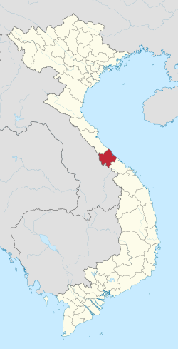
 Location of Quảng Trị within Vietnam |
|
| Coordinates: 16°45′N 107°0′E / 16.750°N 107.000°ECoordinates: 16°45′N 107°0′E / 16.750°N 107.000°E | |
| Country |
|
| Region | North Central Coast |
| Capital | Đông Hà |
| Area | |
| • Total | 4,745.7 km2 (1,832.3 sq mi) |
| Population (2004) | |
| • Total | 616,600 |
| • Density | 130/km2 (340/sq mi) |
| Demographics | |
| • Ethnicities | Vietnamese, Bru – Vân Kiều, Hoa, Tà Ôi |
| Time zone | ICT (UTC+7) |
| Area codes | 233 |
| ISO 3166 code | VN-25 |
| Website | www |
Quảng Trị (Vietnamese: [kwa᷉ːŋ tʂîˀ]) is a province on the North Central Coast region of Vietnam, north of the former imperial capital of Huế.
Located in northern Central Vietnam, Quảng Trị Province is surrounded by Quảng Bình Province on the north, Thừa Thiên-Huế Province on the south, Savannakhet, Laos on the west, and the East Sea on the east, with 75 kilometres (47 mi) of seaside. Except for the narrow piedmont coastal plains, the terrain is dominated by hills and the Annamite Mountains.
The highlands, characterized by steep slopes, sharp crests, and narrow valleys, are covered mainly by a dense broadleaf evergreen forest. Most of the peaks are from 4,000 feet (1,200 m) to 7,000 feet (2,100 m) feet high, but some rise above 8,000 feet (2,400 m). The narrow coastal plains flanking the highlands on the east have rocky headlands and consist of belts of sand dunes and, in areas where the soil is suitable, rice fields. From the crests that mark the drainage divide in the highlands, streams flow either east towards the East Sea or west into Laos or Cambodia. Those flowing eastward follow short courses through deep narrow valleys over rocky bottoms until they reach the coastal plains, where they slow down and disperse. The westward flowing streams follow longer traces, sometimes through deep canyons which are subject to seasonal flooding. The weather features a wide range of temperatures and rainfall, with hot and dry south-west winds during the Southwest Monsoon (May to September), and much cooler wet weather during the rainy season (November to mid-March). Annual average temperature is 24 °C (75 °F), but temperatures can drop as low as 7 °C (45 °F) during the rainy season.
4,760.1 square kilometres (1,837.9 sq mi)
625,800 inhabitants (2006)
Đông Hà City
In the immediate prehistorical period, the lowlands of Quảng Trị and central Vietnam as a whole were occupied by Cham peoples (Champa), speaking a Malayo-Polynesian language, and culturally distinct from the Vietnamese to the north along the Red River. The Qin conquered parts of present-day Central Vietnam at the end of the 3rd century BCE, and administered the indigenous peoples of the area through a commandery, Rinan, for several centuries. A rebellion by the Cham in the 2nd century CE overthrew Chinese control and reestablished local government. Beginning in the 14th and 15th centuries, the Chams were defeated in the area by Vietnamese armies, and ethnic Vietnamese gradually displaced or absorbed those Chams who had not fled. Over time a distinct Vietnamese dialectical and cultural subgroup developed in the area. The region was seized by the French by 1874. In 1887 it became part of French Indochina, i.e. the Annam protectorate.
...
Wikipedia
