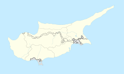
Pyla
|
Pyla |
|
|---|---|

A view from Pyla
|
|
| Coordinates: 35°01′45″N 33°41′30″E / 35.02917°N 33.69167°ECoordinates: 35°01′45″N 33°41′30″E / 35.02917°N 33.69167°E | |
| Country |
|
| District | Larnaca District |
| Population (2011) | |
| • Total | 2,771 |
| Time zone | EET (UTC+2) |
| • Summer (DST) | EEST (UTC+3) |
Pyla (Greek: Πύλα; Turkish: Pile) is a village in Larnaca District, Cyprus. It is one of only four villages located within the United Nations Buffer Zone, the other three being Athienou, Troulloi and Deneia. Pyla is located in the eastern part of the island, adjacent to the British Sovereign Base Area of Dhekelia. From a legal point of view, it is administered as all other areas controlled by both the government of the Turkish Republic of Northern Cyprus and partially by the Greek Republic of Cyprus.
The village is special in the respect that it is the only settlement in Cyprus still inhabited by both its original Greek Cypriot and Turkish Cypriot inhabitants. 850 of the inhabitants are Greek Cypriots and 487 are Turkish Cypriots. The village has three churches and one mosque.
Pyla-Kokkinokremos is an archaeological site dating to the Late Bronze Age.
Pyla is among the oldest villages in Cyprus. The village was first inhabited during the Middle Ages. In several old maps is marked with the names: Pila or Pilla.
The name of the village is Greek which leads to the assumption that the village existed during the Byzantine years. The name "Pyla" is after the Greek word "πύλη" (entrance), probably because it was the only way to travel to the plain of Mesaoria.
...
Wikipedia

