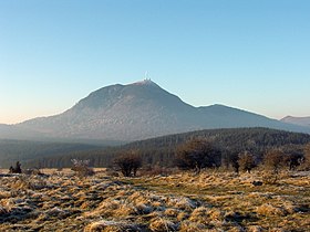
Puy-de-Dôme (mountain)
| Puy de Dôme | |
|---|---|

General view
|
|
| Highest point | |
| Elevation | 1,465 m (4,806 ft) |
| Coordinates | 45°46′19.2″N 02°57′44.64″E / 45.772000°N 2.9624000°ECoordinates: 45°46′19.2″N 02°57′44.64″E / 45.772000°N 2.9624000°E |
| Geography | |
| Location | Puy-de-Dôme, Auvergne, France |
| Parent range | Chaîne des Puys region of Massif Central |
| Geology | |
| Mountain type | Lava dome |
| Last eruption | ca 10,700 years ago |
| Climbing | |
| First ascent | Unknown |
| Easiest route | road |
Puy de Dôme (French pronunciation: [pɥi də dom]; (Auvergnat Puèi Domat, Puèi de Doma) is a large lava dome and one of the youngest volcanoes in the Chaîne des Puys region of Massif Central in central France. This chain of volcanoes including numerous cinder cones, lava domes, and maars is far from the edge of any tectonic plate. Puy de Dôme is approximately 10 kilometres (6 mi) from Clermont-Ferrand. The Puy-de-Dôme département (with hyphens) is named after the volcano.
In pre-Christian Europe, Puy de Dôme served as an assembly place for spiritual ceremonies. Temples were built at the summit, including a Gallo-Roman temple dedicated to the God Mercury, the ruins of which were discovered in 1873.
In 1648, Florin Périer, at the urging of Blaise Pascal, proved Evangelista Torricelli's theory that barometric observations were caused by the weight of air by measuring the height of a column of mercury at three elevations on Puy de Dôme.
In 1875, a physics laboratory was built at the summit. Since 1956, a TDF (Télédiffusion de France) antenna is also located there. On the top of the mountain, there is a transmitter for FM and TV.
...
Wikipedia

