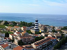
Punta del Faro

Capo Peloro Lighthouse
|
|
|
Sicily
|
|
| Location | Capo Peloro Messina Sicily Italy |
|---|---|
| Coordinates | 38°16′05.6″N 15°39′02.5″E / 38.268222°N 15.650694°E |
| Year first constructed | 1853 (first) |
| Year first lit | 1884 (current) |
| Construction | masonry tower |
| Tower shape | octagonal prism tower with balcony and lantern atop 1-storey keeper’s house |
| Markings / pattern | white and black horizontal bands tower, grey metallic lantern dome |
| Height | 37 metres (121 ft) (current) 42 metres (138 ft) (first) |
| Focal height | 37 metres (121 ft) |
| Current lens | type OR D4 |
| Light source | mains power |
| Intensity | 1,000 w |
| Range | main: 19 nautical miles (35 km; 22 mi) reserve: 13 nautical miles (24 km; 15 mi) |
| Characteristic | Fl (2) G 10s. Iso R 5s. at 22 metres (72 ft) |
| Admiralty number | E1806 |
| NGA number | 9784 |
| ARLHS number | ITA-031 |
| Italy number | 2736 E.F. |
| Managing agent | Marina Militare |
Punta del Faro is the northeastern promontory of Sicily situated in Messina province, northeast of the city of Messina.
As the ancient Pelorus, Punta del Faro is one of the most celebrated promontories of Sicily, forming the northeastern extremity of the whole island, and one of the three promontories which were considered to give to it the triangular form from which it derived the name of "Trinacria". It was at the same time the point which projected furthest towards the opposite coast of Italy; so that the narrowest part of the Sicilian straits was that which lay between Cape Pelorus and the coast adjoining the headland of Caenys (It. Cenide, modern Punta del Pezzo) on the coast of Bruttium (modern Calabria), therefore the nearest points of the Strait of Messina.
A strange story is told by some Roman writers that it derived its ancient name from the pilot of Hannibal, who was put to death by that general from a suspicion of treachery; thus overlooking the fact that it was known by that name to the Greeks for centuries before the time of Hannibal. The actual headland of Pelorus, now called the Capo del Faro, is a low, sandy point; but about 3 km from its extremity there begins a ridge of hills which quickly rises into a range of mountains, of no great elevation, but steep and strongly marked. These continue in an unbroken range at the back of Messina, near which they attain a height of about 1000 m, and flank the east coast of the island as far as the neighborhood of Taormina, where they turn abruptly to the west and stretch across in that direction without any real interruption, until they join the more lofty group of the Monte Madonia. It is to this range of mountains that the name of "Mons Neptunius" is applied by Solinus called today mounts Peloritani, and which that author describes as separating the Tyrrhenian and Adriatic (i. e. Sicilian) seas. But there is no real geographical line of separation between these mountains and those further west, which were known to the ancients as the "Mons Nebrodes".
...
Wikipedia

