Pune Camp
|
Pune Camp Pune Cantonment Pune Camp, पुणे छावणी |
||
|---|---|---|
| city | ||

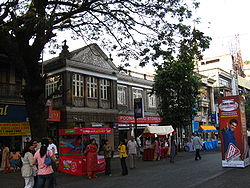
MG Road in Pune Cantonment
|
||
|
||

Pune Camp
|
||
| Coordinates: 18°25′25″N 73°54′32″E / 18.42361°N 73.90889°ECoordinates: 18°25′25″N 73°54′32″E / 18.42361°N 73.90889°E | ||
| Country |
|
|
| State | Maharashtra | |
| Region | Paschim Maharashtra | |
| Division | Pune | |
| District | Pune | |
| Established | 1817 | |
| Talukas | Haveli taluka | |
| Government | ||
| • Body | Pune Cantonment Board | |
| • Cantonment Executive Officer | Shri. Sanjeev Kumar | |
| Area | ||
| • Total | 11.9 km2 (4.6 sq mi) | |
| Elevation | 577 m (1,893 ft) | |
| Population (2005) | ||
| • Total | 79,454 | |
| • Density | 6,700/km2 (17,000/sq mi) | |
| Languages | ||
| • Official | Marathi | |
| Time zone | IST (UTC+5:30) | |
| PIN | 411 0xx | |
| Telephone code | (91)20 | |
| Vehicle registration | MH 12 | |
| Lok Sabha constituency | Pune | |
| Vidhan Sabha constituency | Pune Cantonment | |
| Civic agency | Pune Cantonment Board | |
| Distance from Mumbai | 158 kilometres (98 mi) NNE (road) | |
| Climate | Tropical Wet & Dry (Köppen) | |
| Avg. annual temperature | 24 °C (75 °F) | |
| Avg. summer temperature | 30 °C (86 °F) | |
| Avg. winter temperature | 12 °C (54 °F) | |
| Website | www |
|
Pune Cantonment, also known as Pune Camp, is a military cantonment located in Pune, Maharashtra in India. It was established in 1918 for accommodating troops of the British Indian Army. The cantonment houses many military establishments. It is also known for its many shopping locations like MG Road and East Street. The headquarters of Indian Army's Southern Command is located in Pune Cantonment. The National War Memorial Southern Command which commemorates the sacrifice of soldiers of the Indian Armed Forces is also situated in the cantonment.
The British Indian Army already had a small encampment west of the Mula River in Khadki. As more troops were required to be accommodated, a larger area was occupied to the west of the Mutha River, leading to the establishment of the Pune Cantonment in 1817 for accommodating troops of the British Indian Army. The villages of Mali, Munjeri, Wanowrie and Ghorpuri (Ghorpadi) were selected for this purpose. Initially, a garrison for 4,620 troops was planned for the cantonment. This included two European regiments, a mountain battery, a native cavalry and three native regiments. A central belt of 130 acres (0.53 km2) was designated for training and drills. The firing ranges were located at Golibar Maidan. Soon a large number of civilians began settling in the area. This was encouraged since civilians provided services to troops garrisoned in the cantonment.
The limit of the cantonment were extended in 1822. In 1963, Ghorpuri Village (Ghorpadi) and Fatima Nagar were merged into cantonment area. The limit of the cantonment was again extended in the same year when Mundhwa village was included in the cantonment.
Pune Cantonment is a part of the Pune Lok Sabha constituency. Pune Cantonment is a separate constituency of the Maharashtra Legislative Assembly (Vidhan Sabha). The currently elected Member of Legislative Assembly from Pune Cantonment constituency is Dilip Kamble.
...
Wikipedia

