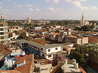
Puerto Principe, Cuba
| Camagüey | ||
|---|---|---|
| City | ||

Camagüey
|
||
|
||
 Camagüey municipality (red) within Camagüey Province (yellow) and Cuba |
||
| Location of Camagüey in Cuba | ||
| Coordinates: 21°23′2″N 77°54′27″W / 21.38389°N 77.90750°WCoordinates: 21°23′2″N 77°54′27″W / 21.38389°N 77.90750°W | ||
| Country |
|
|
| Province | Camagüey | |
| Founded | 1528 | |
| Area | ||
| • Total | 1,106 km2 (427 sq mi) | |
| Elevation | 95 m (312 ft) | |
| Population (2011) | ||
| • Total | 321,992 | |
| • Density | 290/km2 (750/sq mi) | |
| Demonym(s) | Camagüeyano | |
| Time zone | EST (UTC-5) | |
| Postal code | 70100 | |
| Area code(s) | +53 322 | |
| Climate | Aw | |
| Official name | Historic Centre of Camagüey | |
| Type | Cultural | |
| Criteria | iv, v | |
| Designated | 2008 | |
| Reference no. | 1270 | |
| State Party | Cuba | |
| Region | Latin America and the Caribbean | |
Camagüey (Spanish pronunciation: [kamaˈɣwej]) is a city and municipality in central Cuba and is the nation's third largest city with more than 321,000 inhabitants. It is the capital of the Camagüey Province.
After almost continuous attacks from pirates the original city (founded as Santa María del Puerto del Príncipe around 1515 on the northern coast) was moved inland in 1528.
The new city was built with a confusing lay-out of winding alleys. There are many blind alleys and forked streets that lead to squares of different sizes. One explanation is that this was done by design, to make the city easier to defend from any raiders; by the same version, the reason that there is only one exit from the city was that should pirates ever return and succeed in entering the city, it would be possible for local inhabitants to entrap and kill them. However, locals dispute this reasoning as a myth, asserting that in truth the city developed without planning, and that winding streets developed out of everybody wanting to stay close to their local church (the city has 15 of them).
Located on a plain in the middle of its province, the municipality borders with Vertientes, Florida, Esmeralda, Sierra de Cubitas, Minas, Sibanicú and Jimaguayú.
The symbol of the city of Camagüey is the clay pot or tinajón, used to capture rain water to be used later, keeping it fresh. Clay pots are everywhere, some as small as a hand, some large enough for two people to stand up in, either as monuments or for real use. Local legend has it that if you drink water from a girl's personal tinajón, you will fall in love with the girl and never leave her. The main secondary education institutions are the University of Camagüey and the Instituto Pedagógico de Camagüey.
...
Wikipedia


