Puente Hills
| Puente Hills | |
|---|---|

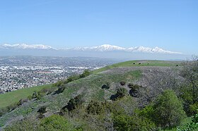
View of the San Gabriel Mountains from the Puente Hills.
|
|
| Highest point | |
| Peak | Workman Hill |
| Elevation | 424 m (1,391 ft) |
| Geography | |
|
location of Puente Hills in California
|
|
| Country | United States |
| State | California |
| District | Los Angeles County |
| Range coordinates | 33°59′59″N 117°55′03″W / 33.9997°N 117.9176°WCoordinates: 33°59′59″N 117°55′03″W / 33.9997°N 117.9176°W |
| Topo map | USGS La Habra |
The Puente Hills is a chain of hills, one of the lower Transverse Ranges, in an unincorporated area in eastern Los Angeles County, California, USA. The western end of the range is often referred to locally as the Whittier Hills.
The Puente Hills lie to the south of the San Gabriel Valley and the Pomona Freeway (State Route 60), to the east of the San Gabriel River Freeway (Interstate 605), to the north of Whittier Boulevard, and to the west of the city of Diamond Bar and Chino Hills. Cities to its north are the City of Industry, Hacienda Heights, and Rowland Heights. To the south are Whittier, La Habra Heights, and Brea. The Brea-Olinda Oil Field, discovered in 1880 and still producing in 2014, is in the southernmost portion of the hills adjacent to the city of Brea.
The Puente Hills are in the California chaparral and woodlands ecoregion of the California Floristic Province. The remnant California native plants here are in the chaparral and oak woodland plant communities, with stands of California native grasses. Vascular Plants of the Whittier Hills, a floristic study, was completed by Julie A. Schneider Ljubenkov and Timothy S. Ross (2001), and published in Crossosoma. It built on the work of Bob Muns.
...
Wikipedia

