Pruem
| Prüm | ||
|---|---|---|
 |
||
|
||
| Coordinates: 50°12′29″N 6°25′28″E / 50.20806°N 6.42444°ECoordinates: 50°12′29″N 6°25′28″E / 50.20806°N 6.42444°E | ||
| Country | Germany | |
| State | Rhineland-Palatinate | |
| District | Eifelkreis Bitburg-Prüm | |
| Municipal assoc. | Prüm | |
| Government | ||
| • Mayor | Mathilde Weinandy (CDU) | |
| Area | ||
| • Total | 22.86 km2 (8.83 sq mi) | |
| Elevation | 460 m (1,510 ft) | |
| Population (2015-12-31) | ||
| • Total | 5,488 | |
| • Density | 240/km2 (620/sq mi) | |
| Time zone | CET/CEST (UTC+1/+2) | |
| Postal codes | 54595 | |
| Dialling codes | 06551 | |
| Vehicle registration | BIT, PRÜ | |
| Website | www.pruem.de | |
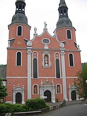
Prüm (German pronunciation: [ˈpʁʏm]) is a town in the Westeifel (Rhineland-Palatinate), Germany. Formerly a district capital, today it is the administrative seat of the Verbandsgemeinde ("collective municipality") Prüm.
Prüm lies on the river Prüm (a tributary of the Sauer) at the southeastern end of the Schneifel, which is 697 m high. Prüm is eponymous for the Prüm syncline (ger. Prümer Kalkmulde), the largest of the Eifel-lime-synclines. Here, the only GSSP-point in Germany identifies the geological border between the lower Devonian Emsian and the middle Devonian Eifelian.
See main article on the town's former monastery, Prüm Abbey. In 2005, the Prüm Convention was signed in the city by several European countries.
Among the largest employers in the region are MUH Arla, Stihl, Streif, Prüm-Türenwerk and Grohmann Engineering. MUH Arla has its head office at Pronsfeld, 10 kilometres away.
Since 1980 it has not been possible to take the train to Prüm, with the exception of freight trains that operated up to the end of the 1990s. In December 2000 the last train went through Prüm, and this was a special event. Since that time, the rail tracks have been dismantled.
The federal highway B265 and B410 cross in Prüm, the autobahn A60 and B51 also run near the city.
...
Wikipedia


