Princeton, Missouri
| Princeton, Missouri | |
|---|---|
| City | |

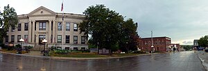
Mercer County Courthouse and downtown
|
|
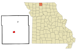
 Location of Princeton, Missouri |
|
| Coordinates: 40°23′56″N 93°35′9″W / 40.39889°N 93.58583°WCoordinates: 40°23′56″N 93°35′9″W / 40.39889°N 93.58583°W | |
| Country | United States |
| State | Missouri |
| County | Mercer |
| Area | |
| • Total | 1.60 sq mi (4.14 km2) |
| • Land | 1.59 sq mi (4.12 km2) |
| • Water | 0.01 sq mi (0.03 km2) |
| Elevation | 961 ft (293 m) |
| Population (2010) | |
| • Total | 1,166 |
| • Estimate (2012) | 1,148 |
| • Density | 733.3/sq mi (283.1/km2) |
| Time zone | Central (CST) (UTC-6) |
| • Summer (DST) | CDT (UTC-5) |
| ZIP code | 64673 |
| Area code(s) | 660 |
| FIPS code | 29-59942 |
| GNIS feature ID | 0724937 |
Princeton is the county seat and largest city of Mercer County, Missouri. The population was 1,166 at the 2010 census, up from the 2000 census, which counted 1,047 people.
Princeton is located at 40°23′56″N 93°35′9″W / 40.39889°N 93.58583°W (40.398794, -93.585807). According to the United States Census Bureau, the city has a total area of 1.60 square miles (4.14 km2), of which, 1.59 square miles (4.12 km2) is land and 0.01 square miles (0.03 km2) is water.
Princeton was platted in 1846. The city was named in commemoration of the Battle of Princeton in the American Revolutionary War. A post office has been in operation at Princeton since 1846.
The Herbert Cain and Corah Brantley Casteel House and Leo Ellis Post No. 22, American Legion Building are listed on the National Register of Historic Places.
As of the census of 2010, there were 1,166 people, 525 households, and 282 families residing in the city. The population density was 733.3 inhabitants per square mile (283.1/km2). There were 632 housing units at an average density of 397.5 per square mile (153.5/km2). The racial makeup of the city was 98.9% White, 0.3% African American, 0.2% Native American, 0.2% Asian, 0.3% from other races, and 0.2% from two or more races. Hispanic or Latino of any race were 0.8% of the population.
...
Wikipedia
