Price Hill, Cincinnati
| Price Hill | |
|---|---|
| Neighborhood of Cincinnati | |
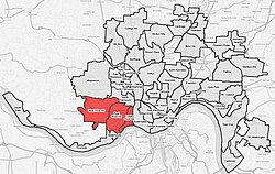
 Price Hill (red) within Cincinnati, OH |
|
| Coordinates: 39°06′36″N 84°34′33″W / 39.110059°N 84.575778°WCoordinates: 39°06′36″N 84°34′33″W / 39.110059°N 84.575778°W | |
| Country | United States |
| State | Ohio |
| County | Hamilton County |
| City | Cincinnati |
| Area | |
| • Total | 6.32 sq mi (16.4 km2) |
| Population | |
| • Total | 40,000 |
| ZIP codes | parts of 45205, 45238, and 45204 |
Price Hill is actually three neighborhoods of Cincinnati, Ohio, located north of Sedamsville and Riverside, south of Westwood and South Fairmount, and west of Queensgate. It is one of the oldest outlying settlements of Cincinnati, and includes parts of the zip codes 45205, 45238, and 45204.
Price Hill covers a little over six square miles, with over 31,000 residents. It is commonly subdivided into East Price Hill, West Price Hill, and Lower Price Hill.
East Price Hill covers 3 square miles (7.8 km2), and has 15,340 residents, according to the 2010 census. As of 2010, 35.1% of the households had one person in the home and 64.9% had two people or more. According to the 2010 Census, 52.0% of the residents were white, 38.3% were black and 6.9% were Hispanic. The region contains part of Mt. Echo Park, Wilson Commons and Olden View Park (all with stunning views of downtown and the river) as well as all of Glenway Woods, Glenway Park, Dempsey Playground and Mayfield Park.
West Price Hill covers 2.75 square miles (7.1 km2), and contains 15,320 residents, according to the 2010 census. As of 2010, 34.7% of the households had one person, 65.3% had two people or more living in the home. The 2010 Census lists 71.5% of the residents as white and 22.1% as black and 4.2% as Hispanic. The region includes Rapid Run Park, the Dunham Recreation Complex, Hendy Memorial Playground, Miles Edwards Park and Bruening Park.
Lower Price Hill is in the river valley to the southwest, comprising 0.57 square miles (1.5 km2). It was known as Eighth and State until recently, getting that name from the major intersection at its center. The 2010 Census lists the population as 1217, though it does not clearly demarc the line between Lower Price Hill and Queensgate, the neighboring industrial area that has little to no population. As of 2010, 22.0% of the households had one person, 78.0% had two people or more living in the home. The 2010 Census lists 61.5% of the residents as white and 25.8% as black with the Hispanic population listed at 12.3%. The region includes part of Mount Echo Park, and the Lower Price Hill Historic District.
...
Wikipedia
