Preah Vihear Province
|
Preah Vihear ព្រះវិហារ |
|
|---|---|
| Province | |

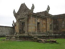
Prasat Preah Vihear
|
|
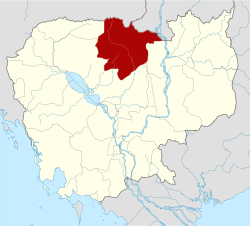
 Map of Cambodia highlighting Preah Vihear |
|
| Coordinates: 13°47′N 104°58′E / 13.783°N 104.967°ECoordinates: 13°47′N 104°58′E / 13.783°N 104.967°E | |
| Country |
|
| Provincial status | 1959 |
| Named for | Preah Vihear Temple |
| Capital | Tbeng Meanchey |
| Government | |
| • Governor | Un Chanda (CPP) |
| Area | |
| • Total | 13,788 km2 (5,324 sq mi) |
| Area rank | Ranked 3rd |
| Population (2008) | |
| • Total | 170,852 |
| • Rank | Ranked 19th |
| • Density | 12/km2 (32/sq mi) |
| • Density rank | Ranked 23rd |
| Time zone | UTC+07 |
| Dialing code | +855 |
| ISO 3166 code | KH-13 |
| Districts | 7 |
Preah Vihear (Khmer: ព្រះវិហារ, IPA: [preə̯̆h ʋihiə]; "Sacred Sanctuary") is a province (khaet) of Cambodia. It borders the provinces of Oddar Meanchey and Siem Reap to the west, Kampong Thom to the south and Stung Treng to the east. Its northern boundary forms part of Cambodia's international border with Thailand and Laos. Its capital is Tbeng Meanchey town.
The province is named after the temple of Prasat Preah Vihear. The Dângrêk Mountains and the Cambodia/Thailand border are located in the north of Preah Vihear Province.
Preah Vihear is one of the nine provinces that are part of the Tonle Sap Biosphere Reserve.
Several Western governments have issued travel warnings to their citizens advising not to travel to this province due to an ongoing border dispute between Cambodia and Thailand. The Government of Canada has advised "Armed forces from both countries are engaged in this ongoing dispute. There have been reports of exchanges of gunfire in the area. Tensions are extremely high and military hostilities could escalate without warning."
The province is subdivided into 7 districts.
...
Wikipedia
