Kampong Thom Province
|
Kampong Thom ខេត្តកំពង់ធំ |
|
|---|---|
| Province | |

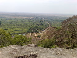
Phnom Santuk
|
|
 Map of Cambodia highlighting Kampong Thom |
|
| Coordinates: 12°42′N 104°53′E / 12.700°N 104.883°ECoordinates: 12°42′N 104°53′E / 12.700°N 104.883°E | |
| Country |
|
| Provincial status | 1907 |
| Capital | Stueng Saen |
| Government | |
| • Governor | Uth Sam An (CPP) |
| Area | |
| • Total | 13,814 km2 (5,334 sq mi) |
| Area rank | Ranked 2nd |
| Population (2009) | |
| • Total | 708,398 |
| • Rank | Ranked 11th |
| • Density | 51/km2 (130/sq mi) |
| • Density rank | Ranked 17th |
| Time zone | UTC+07 |
| Dialing code | +855 |
| ISO 3166 code | KH-6 |
| Districts | 8 |
Kampong Thom (Khmer: កំពង់ធំ, IPA: [kɑmpɔːŋ tʰom], "Great Port") is a province (khaet) of Cambodia. It borders the provinces of Siem Reap to the northwest, Preah Vihear to the north, Stung Treng to the northeast, Kratie to the east, Kampong Cham, Kampong Chhnang to the south, and the Tonle Sap to the west.
The provincial capital is Stung Saen, a town of approximately 30,000 people on the banks of the Stung Sen River.
Kampong Thom is Cambodia's second largest province by area. There are a number of significant Angkorian sites in the area, including Prasat Sambor Prei Kuk and Prasat Andet temples. As one of the nine provinces bordering Tonle Sap Lake, Kampong Thom is part of the Tonlé Sap Biosphere Reserve.
The province is subdivided into 8 districts.
The previous name of the province was Kampong Pous Thom (Port/City of the Great Snakes). According to local legend, at a lakeside dock near the Sen River, a pair of large snakes inhabited a nearby cave. On every Buddhist holiday, the snakes would make appearances to the people nearby who then began to refer to the area as Kampong Pous Thom. Eventually the snakes disappeared and the name was shortened to Kampong Thom. During the Colonial Cambodia period, the French divided Cambodian territory into provinces and named most of them according to the local popular names for the respective areas.
...
Wikipedia
