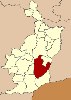
Prakhon Chai District
|
Prakhon Chai ประโคนชัย |
|
|---|---|
| Amphoe | |
 Amphoe location in Buriram Province |
|
| Coordinates: 14°36′24″N 103°7′18″E / 14.60667°N 103.12167°ECoordinates: 14°36′24″N 103°7′18″E / 14.60667°N 103.12167°E | |
| Country | Thailand |
| Province | Buriram |
| Seat | Prakhon Chai |
| Area | |
| • Total | 890.121 km2 (343.678 sq mi) |
| Population (2005) | |
| • Total | 132,141 |
| • Density | 147.3/km2 (382/sq mi) |
| Time zone | ICT (UTC+7) |
| Postal code | 31140 |
| Geocode | 3107 |
Prakhon Chai (Thai: ประโคนชัย, pronounced [prā.kʰōːn t͡ɕʰāj]) is a district (amphoe) in the southern part of Buriram Province, northeastern Thailand.
Neighboring districts are (from the south clockwise) Ban Kruat, Lahan Sai, Chaloem Phra Kiat, Nang Rong, Mueang Buriram, Phlapphla Chai of Buriram Province and Prasat of Surin Province.
The district was renamed from Talung (ตะลุง) to Prakhon Chai in 1939.
In 1964, artwork depicting Buddhist figures, including Avalokitesvara, was discovered in Prakhon Chai. Originating from the pre-Angkor period, these figures reflect traditional Indian styles, as passed down through the Cambodian tradition of the Chenla Kingdom.
The district is divided into 16 sub-districts (tambon), which are further subdivided into 199 villages (muban). Prakhon Chai is a township (thesaban tambon) which covers parts of tambon Prakhon Chai. There are also 16 tambon administrative organizations (TAO).
Missing numbers are tambon which now form Phlapphla Chai district.
...
Wikipedia
