Prairie du Sac, Wisconsin
| Prairie du Sac, Wisconsin | |
|---|---|
| Village | |

Downtown Prairie du Sac
|
|
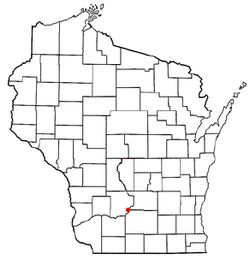
 Location of Prairie du Sac, Wisconsin |
|
| Coordinates: 43°16′44″N 89°47′16″W / 43.27889°N 89.78778°WCoordinates: 43°16′44″N 89°47′16″W / 43.27889°N 89.78778°W | |
| Country | United States |
| State | Wisconsin |
| County | Sauk |
| Area | |
| • Total | 1.66 sq mi (4.30 km2) |
| • Land | 1.55 sq mi (4.01 km2) |
| • Water | 0.11 sq mi (0.28 km2) |
| Elevation | 768 ft (234 m) |
| Population (2010) | |
| • Total | 3,972 |
| • Estimate (2012) | 4,112 |
| • Density | 2,562.6/sq mi (989.4/km2) |
| Time zone | Central (CST) (UTC-6) |
| • Summer (DST) | CDT (UTC-5) |
| Area code(s) | 608 |
| FIPS code | 55-65125 |
| GNIS feature ID | 1583974 |
| Website | http://www.prairiedusac.net |
Prairie du Sac is a village in Sauk County, Wisconsin, United States. The population was 3,972 at the 2010 census. The village is surrounded by the Town of Prairie du Sac, the Wisconsin River, and the village of Sauk City; together, Prairie du Sac and Sauk City are referred to as Sauk Prairie.
Prairie du Sac was so named because it was in the large Wisconsin River Valley where the Sauk Indians had a large settlement. Although the name of the village dates from the early days of French fur traders, Prairie du Sac was established as a village by D.B. Crocker in 1840, largely as a Yankee-English village, in contrast to its neighbor, Sauk City, which was settled largely by Germans.
Prairie du Sac is located at 43°17′23″N 89°43′42″W / 43.28972°N 89.72833°W (43.289833, -89.728524).
According to the United States Census Bureau, the village has a total area of 1.66 square miles (4.30 km2), of which, 1.55 square miles (4.01 km2) of it is land and 0.11 square miles (0.28 km2) is water.
Prairie du Sac is serviced by the Sauk-Prairie Airport (91C).
As of the census of 2010, there were 3,972 people, 1,649 households, and 1,075 families residing in the village. The population density was 2,562.6 inhabitants per square mile (989.4/km2). There were 1,733 housing units at an average density of 1,118.1 per square mile (431.7/km2). The racial makeup of the village was 94.3% White, 0.6% African American, 0.3% Native American, 0.6% Asian, 2.7% from other races, and 1.5% from two or more races. Hispanic or Latino of any race were 4.8% of the population.
...
Wikipedia
