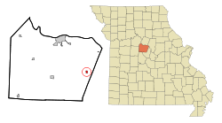
Prairie Home
| Prairie Home, Missouri | |
|---|---|
| City | |
 Location of Prairie Home, Missouri |
|
| Coordinates: 38°48′47″N 92°35′23″W / 38.81306°N 92.58972°WCoordinates: 38°48′47″N 92°35′23″W / 38.81306°N 92.58972°W | |
| Country | United States |
| State | Missouri |
| County | Cooper |
| Area | |
| • Total | 0.39 sq mi (1.01 km2) |
| • Land | 0.39 sq mi (1.01 km2) |
| • Water | 0 sq mi (0 km2) |
| Elevation | 889 ft (271 m) |
| Population (2010) | |
| • Total | 280 |
| • Estimate (2016) | 283 |
| • Density | 720/sq mi (280/km2) |
| Time zone | Central (CST) (UTC-6) |
| • Summer (DST) | CDT (UTC-5) |
| ZIP code | 65068 |
| Area code(s) | 660 |
| FIPS code | 29-59726 |
| GNIS feature ID | 0724867 |
Prairie Home is a town, with legal status as a city, in Cooper County, Missouri, United States. The population was 280 at the 2010 census.
The town of Prairie Home was laid out in 1874 around the Prairie Home Institute, a school which had been built some time earlier. Prairie Home is a descriptive name, referring to its scenic setting on the prairie.
Prairie Home is located at 38°48′47″N 92°35′23″W / 38.81306°N 92.58972°W (38.813012, -92.589786), along Missouri Route 87 and near its intersection with Route J. According to the United States Census Bureau, the city has a total area of 0.39 square miles (1.01 km2), all of it land.
As of the census of 2010, there were 280 people, 121 households, and 85 families residing in the city. The population density was 717.9 inhabitants per square mile (277.2/km2). There were 132 housing units at an average density of 338.5 per square mile (130.7/km2). The racial makeup of the city was 98.9% White, 0.4% African American, 0.4% Asian, and 0.4% from two or more races. Hispanic or Latino of any race were 0.7% of the population.
...
Wikipedia
