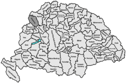
Pozsony county
| Pozsony County Comitatus Posoniensis (Latin) Pozsony vármegye (Hungarian) Komitat Pressburg (German) Prešporská župa (Slovak) |
|||||
| County of the Kingdom of Hungary | |||||
|
|||||
|
Coat of arms |
|||||
| Capital |
Pressburg (Hungarian: Pozsony) 48°9′N 17°7′E / 48.150°N 17.117°ECoordinates: 48°9′N 17°7′E / 48.150°N 17.117°E |
||||
| History | |||||
| • | Established | ca. 1000 | |||
| • | Treaty of Trianon | 4 June 1920 | |||
| Area | |||||
| • | 1910 | 4,370 km2(1,687 sq mi) | |||
| Population | |||||
| • | 1910 | 389,750 | |||
| Density | 89.2 /km2 (231 /sq mi) | ||||
| Today part of |
|
||||
| Bratislava is the current name of the capital. | |||||
Coat of arms
Pozsony county was an administrative county (comitatus) of the Kingdom of Hungary. Its territory lies in present-day western Slovakia.
Its name changed along with that of the city of Pressburg (Hungarian: Pozsony, today's Bratislava). Its names around 1900 were Pozsony vármegye in Hungarian, Prešpurská župa in Slovak and Preßburger Gespanschaft in German.
The county shared borders with the Austrian land of Lower Austria and the Hungarian counties Nyitra, Komárom, Győr and Moson. It was situated between the river Morava in the west, the river Danube in the south, and the river Váh (Hungarian: Vág) in the east. The southern part of the Little Carpathians divided the county into two. It also covered most of the island known today as Žitný ostrov (Hungarian: Csallóköz) between the Danube and the Little Danube. Its area was 4,370 km² around 1910.
...
Wikipedia


