Poulan, Georgia
| Poulan, Georgia | |
|---|---|
| City | |

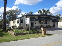
Poulan City Hall and Police Station
|
|
 Location in Worth County and the state of Georgia |
|
| Coordinates: 31°30′49″N 83°47′28″W / 31.51361°N 83.79111°WCoordinates: 31°30′49″N 83°47′28″W / 31.51361°N 83.79111°W | |
| Country | United States |
| State | Georgia |
| County | Worth |
| Area | |
| • Total | 1.7 sq mi (4.3 km2) |
| • Land | 1.7 sq mi (4.3 km2) |
| • Water | 0 sq mi (0 km2) |
| Elevation | 381 ft (116 m) |
| Population (2010) | |
| • Total | 851 |
| • Estimate (2016) | 803 |
| • Density | 600/sq mi (220/km2) |
| Time zone | Eastern (EST) (UTC-5) |
| • Summer (DST) | EDT (UTC-4) |
| ZIP code | 31781 |
| Area code(s) | 229 |
| FIPS code | 13-62496 |
| GNIS feature ID | 0321100 |
Poulan is a city in Worth County, Georgia, United States. The population was 946 at the 2000 census. It was settled circa 1877, and was located along the Brunswick and Albany railroad. The city was named for Judge W.A. Poulan.
Poulan is part of the Albany, Georgia Metropolitan Statistical Area.
Poulan is notorious for its police department's speed trap tactics along six miles of U.S. Route 82. In 2009 Poulan's small police force generated nearly $900,000 in fines and fees, a number comparable to a city 30 times its size and due to the charges and fees being more than most cities. The per capita revenue from fines and fees is $1,019.15.
Poulan is located at 31°30′49″N 83°47′28″W / 31.51361°N 83.79111°W (31.513739, -83.791041).
According to the United States Census Bureau, the city has a total area of 1.7 square miles (4.3 km²), all land.
As of the census of 2000, there were 946 people, 365 households, and 273 families residing in the city. The population density was 571.2 people per square mile (220.0/km²). There were 399 housing units at an average density of 240.9 per square mile (92.8/km²). The racial makeup of the city was 76.22% White, 21.99% African American, 0.42% Native American, 0.11% Asian, 0.53% from other races, and 0.74% from two or more races. Hispanic or Latino of any race were 0.74% of the population.
...
Wikipedia
