Potteric Carr Nature Reserve

The logo of the Wildlife Trusts
|
|
 |
|

`
|
|
| Abbreviation | YWT |
|---|---|
| Motto | Love Yorkshire, Love Wildlife |
| Formation | 1 January 1946 as Yorkshire Naturalists’ Trust |
| Type | Registered charity No.210807 |
| Legal status | Company limited by guarantee No.409650 |
| Purpose | Protecting wildlife and wild places, and educating, influencing and empowering people. |
| Headquarters | 1 St George's Place, York |
| Location |
|
|
Region served
|
Traditional county of Yorkshire |
|
Chief Executive
|
Dr Rob Stoneman |
| Affiliations | The Wildlife Trusts partnership |
|
Budget
|
Accounts |
| Website | http://www.ywt.org.uk/reserves/potteric-carr-nature-reserve Official site] |
| Potteric Carr Nature Reserve | |
|---|---|

Series of bridges crossing over the Mother Drain at Potteric Carr Nature Reserve
|
|
| Location | Mallard Way, Balby, Doncaster, England DN4 8DB |
| Coordinates | 53°29′45″N 1°05′49″W / 53.49574°N 1.09698°W |
| Created | 1968 |
| Operated by | Yorkshire Wildlife Trust |
| Status | Site of Special Scientific Interest |
| Website | www |
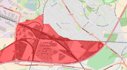
Potteric Carr is a large area of land to the south east of Doncaster, in Yorkshire, England, some 3,000 acres (12 km2) in size.
One of the earliest references to Potteric Carr comes from the itinerary of Leland c.1540: "Before I came to the town, I passed the ford of a brooke, which, as I remember is called Rossington Bridge…. The soil about Doncaster hath very good meadow, corn and some wood". As Leland travelled into Doncaster from Bawtry, he passed through a landscape unfamiliar to us today. Sherwood forest then extended to the very boundaries of Doncaster and venerable oaks dotted the landscape from Bawtry to Hatfield. To the west of the road from Rossington Bridge into Doncaster, Leland passed the "largely impenetrable morass of bog and fen known locally as Potteric Carr". Earlier he would have caught glimpses in the east of a similar wild tract of marshy country which then covered the whole of the flat land between the Don and the Trent. The passage of time has left us with precious little of those former conditions and Potteric Carr in particular has seen many changes. The following sections give a brief description of the changes which have taken place over 2000 years.
At the time of the Roman occupation much of lowland Britain was open farmland with regemented field systems used for agriculture since the Iron Age, which can be seen in Dr Derick Riley's air photographs of nearby Bawtry Road and Hurst Lane where the Roman Till Bridge Lane runs through the earlier Iron Age field systems. However, Most of the land to the east of Doncaster is only a few metres above sea level and consequently would at that time have comprised a vast marshy area. There is evidence that the Romans made some attempts at drainage but their work fell into disrepair on their departure from Britain. Little is known of the next 1000 years but, by the time of Henry VIII, Potteric Carr was just a small part of Hatfield Chase, the largest deer chase in the realm. The chase eventually fell from royal favour about the time of the reign of Elizabeth I, due to its permanently inundated state.
Over the next 150 years a number of largely unsuccessful attempts at draining the Carr were made and during this time a duck decoy was established. The duck decoy was a method, perfected in the Netherlands, of catching ducks. The idea may have been introduced to the area by Dutch workers who came to Britain with Cornelius Vermuyden who is noted for his drainage schemes in the English Fens and the nearby Isle of Axholme. The proceeds from the decoy were distributed amongst the poor of Doncaster. The decoy was operated for about 130 years but its closure was foreshadowed in the 1760s when a civil engineer, John Smeaton, carried out the final and most effective drainage scheme so that by the end of the century much of the area was under agriculture. So successful was the drainage that the only remnant of the original flora was probably confined to a small area in and around the now disused decoy.
...
Wikipedia
