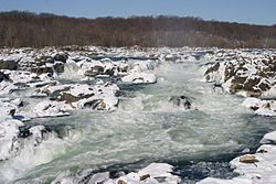
Potomac river
| Potomac River (Wappatomaka) | |
|
Great Falls of the Potomac River in winter
|
|
| Country | United States |
|---|---|
| States | West Virginia, Maryland, Virginia, Washington, D.C. |
| Tributaries | |
| - left | Monocacy River, Anacostia River |
| - right | Shenandoah River, Occoquan River |
| Cities | Harpers Ferry, WV, Cumberland, MD, Washington, D.C., Arlington, VA, Alexandria, VA |
| Source | Fairfax Stone |
| - elevation | 3,060 ft (933 m) |
| - coordinates | 39°11′43″N 79°29′28″W / 39.19528°N 79.49111°W |
| Mouth | Chesapeake Bay |
| - location | St. Mary's County, Maryland / Northumberland County, Virginia, United States |
| - elevation | 0 ft (0 m) |
| - coordinates | 37°59′57″N 76°14′59″W / 37.99917°N 76.24972°WCoordinates: 37°59′57″N 76°14′59″W / 37.99917°N 76.24972°W |
| Length | 405 mi (652 km) |
| Basin | 14,700 sq mi (38,073 km2) |
| Discharge | for Little Falls, near Washington, D.C. (non-tidal) |
| - average | 11,600 cu ft/s (328 m3/s) |
| - max | 484,000 cu ft/s (13,705 m3/s) |
| - min | 66 cu ft/s (2 m3/s) |
| Discharge elsewhere (average) | |
| - Point of Rocks, MD | 7,320 cu ft/s (207 m3/s) |
|
The Potomac River watershed covers the District of Columbia and parts of four states
|
|
The Potomac River /pəˈtoʊmək/ (![]() listen ) is located along the mid-Atlantic Ocean coast of the United States and flows into the Chesapeake Bay. The river (main stem and North Branch) is approximately 405 miles (652 km) long, with a drainage area of about 14,700 square miles (38,000 km²). In terms of area, this makes the Potomac River the fourth largest river along the Atlantic coast of the United States and the 21st largest in the United States. Over 5 million people live within the Potomac watershed.
listen ) is located along the mid-Atlantic Ocean coast of the United States and flows into the Chesapeake Bay. The river (main stem and North Branch) is approximately 405 miles (652 km) long, with a drainage area of about 14,700 square miles (38,000 km²). In terms of area, this makes the Potomac River the fourth largest river along the Atlantic coast of the United States and the 21st largest in the United States. Over 5 million people live within the Potomac watershed.
The river forms part of the borders between Maryland and Washington, D.C., on the left descending bank and West Virginia and Virginia on the river's right descending bank. The majority of the lower Potomac River is part of the State of Maryland. Exceptions include a small tidal portion within the District of Columbia, and the border with Virginia being delineated from "point to point" (thus various bays and shoreline indentations lie in Virginia). Except for a small portion of its headwaters in West Virginia, the North Branch Potomac River is considered part of Maryland to the low water mark on the opposite bank. The South Branch Potomac River lies completely within the state of West Virginia except for its headwaters, which lie in Virginia.
...
Wikipedia


