Potlatch River
| Potlatch River | |
| River | |
|
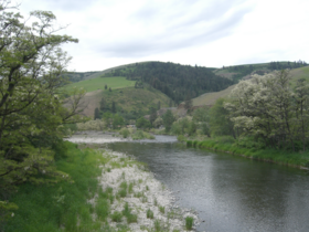
The Potlatch near Kendrick
|
|
| Country | United States |
|---|---|
| State | Idaho |
| Regions | Latah County, Clearwater County, Nez Perce County |
| Part of | Clearwater River |
| Tributaries | |
| - left | Cedar Creek (Idaho) |
| - right | Big Bear Creek |
| Source | Hoodoo Mountains Confluence of East and West Forks |
| - location | Rocky Mountains, Latah County |
| - elevation | 2,674 ft (815 m) |
| - coordinates | 46°55′43″N 116°20′55″W / 46.92861°N 116.34861°W |
| Mouth | Clearwater River |
| - location | Between Myrtle and Spalding, Nez Perce County |
| - elevation | 801 ft (244 m) |
| Length | 56 mi (90 km), Northeast-southwest |
| Basin | 594 sq mi (1,538 km2) |
| Discharge | |
| - average | 379.8 cu ft/s (11 m3/s) |
| - max | 8,150 cu ft/s (231 m3/s) |
| - min | 75 cu ft/s (2 m3/s) |
|
Map of the Clearwater River watershed showing the Potlatch River in the upper left
|
|
The Potlatch River is in the state of Idaho in the United States. About 56 miles (90 km) long, it is the lowermost major tributary to the Clearwater River, a tributary of the Snake River that is in turn a tributary of the Columbia River. Once surrounded by arid grasslands of the Columbia Plateau adjacent to the western foothills of the Rocky Mountains, the Potlatch today is used mainly for agriculture and irrigation purposes.
Its name derives from potlatch, a type of ceremony held by the indigenous people of the Pacific Northwest; one such tribe lived along the river for hundreds of years before the arrival of whites. Pioneers settled the watershed and established farms and ranches in the late 19th century. After that, logging eliminated most of the forests within the watershed and the ecology of the river is still in the process of recovery. Fishing, hiking and camping are popular recreational activities on the river; 14 percent the watershed lies on public lands. Before logging and agriculture, many varieties of riparian and forest plants once populated the catchment, and several species of fish still swim the river and its tributaries.
The Hoodoo Mountains are the source of the Potlatch River. The Potlatch's course traces a southwesterly line across the eastern Columbia Plateau in the arid Rocky Mountain foothills. Two forks form the river's headwaters in the southern part of the Idaho Panhandle. The West Fork drains part of Latah County and the East Fork is in Clearwater County. These two forks combine near Helmer, and soon the river descends into a canyon that continues all the way to the mouth. While in the canyon, it receives Pine, Big Bear, Middle Potlatch and Little Potlatch Creeks from the north, and Boulder and Cedar Creeks from the south. Idaho State Highway 3 follows part of the lower canyon, and the town of Juliaetta is located at the Middle Potlatch Creek confluence. The river merges with the Clearwater at the elevation of 801 feet (244 m) between the towns of Myrtle and Spalding. Its average discharge at the mouth, according to a USGS stream gauge, is 379.8 cubic feet per second (10.75 m3/s). A peak flow of 8,150 cubic feet per second (231 m3/s) was recorded there in 2006. The river reaches its highest peaks in the winter and early spring, while it reduces to a trickle by summer and autumn. The river mainly flows over and through coarse Columbia River basalts that comprise the Columbia Plateau, similar in geology to the Palouse River farther west.
...
Wikipedia


