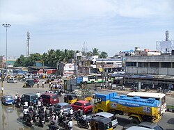
Porur
| PORUR | |
|---|---|
| neighbourhood | |

PORUR JUNCTION
|
|
| Nickname(s): PORUR | |
| PORUR | |
| Coordinates: 13°02′05″N 80°09′21″E / 13.03478°N 80.15586°ECoordinates: 13°02′05″N 80°09′21″E / 13.03478°N 80.15586°E | |
| Country | India |
| State | Tamil Nadu |
| District | Chennai |
| Metro | Chennai |
| Government | |
| • Type | Chennai Corporation |
| • Body | Chennai Corporation |
| Area | |
| • Total | 3.78 km2 (1.46 sq mi) |
| Elevation | 16 m (52 ft) |
| Population (2001) | |
| • Total | 28,783 |
| • Density | 7,600/km2 (20,000/sq mi) |
| Languages | |
| • Official | Tamil |
| Time zone | IST (UTC+5:30) |
| Vehicle registration | TN 10 |
Porur is a residential locality in Chennai metropolitan city its comes under Chennai Corporation (Ward no. 151 and 153 of Zone XI) of the city of Chennai in Tamil Nadu, India. It occupies a crucial position on the Mount-Poonamallee Road, Porur is known for its chemical industries, manufacturing plants, residential colonies and vegetable markets.
Porur is of great antiquity and is believed to have been existent since the Pallava period. It was upgraded from village panchayat to town panchayat on October 1, 1977. Porur is one of the fast-developing places of Chennai. It was included in the Chennai Corporation by the year 2011.
The Porur Lake is the principal source of fresh water for the suburb. Porur is known for the renowned Ramachandra Medical College. Porur houses Mono-pulse Secondary Surveillance radar, one of the two radars in the city, which aids air-transport communication.
Porur is located at 13.03° N and 80.16° E, and 52 feet (15 metres) above sea level. It is bounded on the east and south-east by the Pallavaram Hills. It is located 18 km south-west of Chennai city limits on the Guindy-Poonamalee road which eventually merges into the Chennai-Bangalore highway. For administrative purposes, Porur has been included in Thiruvallur district.
Porur was a little-known village administered as a part of the Saidapet taluk of the then Chingleput district in 1961. During that time, the Saidapet taluk adjoining Madras city, especially the Mount-Poonamallee Road, was famous for industries and chemical plants producing a variety of products.
Porur village panchayat was upgraded to a Grade-I town panchayat on October 1, 1977. Later, it was upgraded to a selection grade town panchayat starting from February 24, 1982. The population of the town at the time of the 1981 census was 8,633. When the Chengalpattu district was bifurcated on January 1, 1997 into Chengalpattu and Thiruvallur districts, Porur became a part of Thiruvallur district..
...
Wikipedia

