Porter, Maine
| Porter, Maine | |
|---|---|
| Town | |

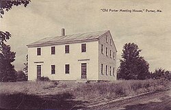
Old Porter Meeting House (built 1828), c. 1922
|
|
| Location within the state of Maine | |
| Coordinates: 43°50′2″N 70°55′51″W / 43.83389°N 70.93083°W | |
| Country | United States |
| State | Maine |
| County | Oxford |
| Incorporated | 1807 |
| Area | |
| • Total | 32.87 sq mi (85.13 km2) |
| • Land | 31.50 sq mi (81.58 km2) |
| • Water | 1.37 sq mi (3.55 km2) |
| Elevation | 466 ft (142 m) |
| Population (2010) | |
| • Total | 1,498 |
| • Estimate (2012) | 1,493 |
| • Density | 47.6/sq mi (18.4/km2) |
| Time zone | Eastern (EST) (UTC-5) |
| • Summer (DST) | EDT (UTC-4) |
| ZIP code | 04068 |
| Area code(s) | 207 |
| FIPS code | 23-60405 |
| GNIS feature ID | 0582682 |
Porter is a town in Oxford County, Maine, United States. It is included in the Portland-South Portland-Biddeford, Maine metropolitan New England City and Town Area. Porter includes Porter village and part of Kezar Falls. The population was 1,498 at the 2010 census.
The land was once territory of Pequawket, the Abenaki village at what it now Fryeburg. It was purchased from the Massachusetts General Court in September 1795 by Dr. Aaron Porter of Biddeford and others. Terms of the grant offered 100 acres (40 ha) to each man who settled before January 1, 1784. First called Portersfield Plantation, it was incorporated as a town on February 20, 1807, named for its principal proprietor. Land was set off to Brownfield in 1831, 1832 and 1855.
Although farmers found the town's surface uneven, the hillsides offered excellent pasturage for cattle. Porter became noted for its orchards. Outlets of ponds provided sites for mills, with the best water power on the Ossipee River at Kezar Falls, where part of the village lies in Parsonsfield. The town had numerous sawmills, a gristmill, furniture factory, bobbin factory and a boot and shoe factory. In 1870, the population was 1,104.
...
Wikipedia

