Portage Township, Cameron County, Pennsylvania
| Portage Township, Cameron County, Pennsylvania |
|
|---|---|
| Township | |

Road through conifers in Sizerville State Park
|
|
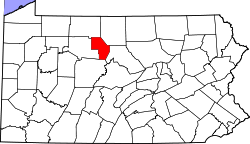
 Map of Cameron County, Pennsylvania highlighting Portage Township |
|
 Map of Cameron County, Pennsylvania |
|
| Country | United States |
| State | Pennsylvania |
| County | Cameron |
| Settled | 1820 |
| Area | |
| • Total | 14.5 sq mi (37.5 km2) |
| • Land | 14.4 sq mi (37.2 km2) |
| • Water | 0.1 sq mi (0.3 km2) |
| Population (2010) | |
| • Total | 171 |
| • Density | 12/sq mi (4.6/km2) |
| Time zone | Eastern (EST) (UTC-5) |
| • Summer (DST) | EDT (UTC-4) |
| Area code(s) | 814 |
Portage Township is a township in Cameron County, Pennsylvania, United States. The population was 171 at the 2010 census, down from 258 at the 2000 census.
Portage Township is located in northeastern Cameron County and has a narrow, north-south-oriented shape. It is bordered by Potter County to the northeast, Lumber Township to the south and east and Shippen Township to the west. The borough of Emporium, the Cameron County seat, is 2 miles (3 km) to the west. The hamlet of Sizerville is in the northern part of the township, next to Sizerville State Park.
According to the United States Census Bureau, the township has a total area of 14.5 square miles (37.5 km2), of which 14.4 square miles (37.2 km2) is land and 0.1 square miles (0.3 km2), or 0.69%, is water. Sinnemahoning Portage Creek, flowing north to south, runs through the northern portion of the township. The creek is part of the Sinnemahoning Creek watershed, which connects to the West Branch Susquehanna River. The headwaters of the creek, to the north in Potter County, rise a short distance south of Allegheny Portage Creek, a north-flowing stream that is part of the Allegheny River system flowing to the Ohio Valley.
As of the census of 2000, there were 258 people, 96 households, and 71 families residing in the township. The population density was 14.2 people per square mile (5.5/km²). There were 136 housing units at an average density of 7.5/sq mi (2.9/km²). The racial makeup of the township was 98.84% White, 0.39% African American, 0.39% Native American and 0.39% Asian. Hispanic or Latino of any race were 0.39% of the population.
...
Wikipedia
