Port Wakefield, South Australia
|
Port Wakefield South Australia |
|||||||||||||
|---|---|---|---|---|---|---|---|---|---|---|---|---|---|

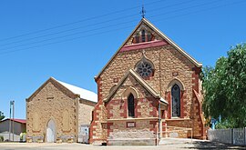
Uniting Church at Port Wakefield
|
|||||||||||||
| Coordinates | 34°11′0″S 138°09′0″E / 34.18333°S 138.15000°ECoordinates: 34°11′0″S 138°09′0″E / 34.18333°S 138.15000°E | ||||||||||||
| Population | 476 (2006 census) | ||||||||||||
| Postcode(s) | 5550 | ||||||||||||
| Location | 99 km (62 mi) North West of Adelaide city centre via |
||||||||||||
| LGA(s) | Wakefield Regional Council | ||||||||||||
| State electorate(s) | Goyder | ||||||||||||
| Federal Division(s) | Wakefield | ||||||||||||
|
|||||||||||||
| Footnotes | Adjoining localities | ||||||||||||
Port Wakefield (formerly Port Henry) was the first government town to be established north of the capital, Adelaide, in South Australia.
Port Wakefield is situated 98.7 kilometres (61.3 mi) from the Adelaide city centre and lies on the Port Wakefield Road section of the A1 National Highway. Port Wakefield is situated on the River Wakefield, at the head of the Gulf St Vincent.
The town was originally named Port Henry by William Hill. The name of the town was, around 1849, changed to Port Wakefield, after the Wakefield River.
In 1848, the Patent Copper Company agreed to build and operate a smelter at Burra. Seeking to reduce cartage costs, a track was surveyed to its port established at the mouth of the River Wakefield. By securing leases of the appropriate Crown Land, the company obtained a monopoly of the port. The Government declared the track the Great Western Road. The wharf was constructed along the bank of the river and cargo was transferred between the wharf and ships at anchor in the Gulf on lighters.
With the opening of the railway from Adelaide to Gawler in 1857, the Copper Company's traffic came to a sudden end, leaving only pastoral produce to flow to the port. Mixed farming was established on lands opening up by the Government along the River in the mid-1860s and this called for improvement in transport to the Port.
William Hanson, Manager for Railways, selected a route for a horse-drawn tramway terminating at Hoyles Plains, later renamed Hoyleton. The enabling Act provided for a tramway of 28 miles 41 chains (45.9 km) in length to a gauge of 1,067 mm (3 ft 6 in), the first line in South Australia built to that gauge. Subsequently, the Government agreed that the line should be operated by a private body. The successful tenderer was one Paul Badcock who opened the line to traffic on 4 January 1870. Horses were worked in three relays between the stations on the route.
...
Wikipedia

