Port Vue, Pennsylvania
| Port Vue | |
|---|---|
| Borough | |

Romine Ave
|
|
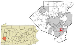
 Location in Allegheny County and the state of Pennsylvania |
|
| Coordinates: 40°20′19″N 79°52′14″W / 40.33861°N 79.87056°WCoordinates: 40°20′19″N 79°52′14″W / 40.33861°N 79.87056°W | |
| Country | United States |
| State | Pennsylvania |
| County | Allegheny |
| Area | |
| • Total | 1.1 sq mi (3 km2) |
| • Land | 1.1 sq mi (3 km2) |
| • Water | 0.04 sq mi (0.1 km2) |
| Population (2010) | |
| • Total | 3,798 |
| • Density | 3,500/sq mi (1,300/km2) |
| Time zone | Eastern (EST) (UTC-5) |
| • Summer (DST) | EDT (UTC-4) |
| Website | Borough of Port Vue |
Port Vue is a borough in Allegheny County, Pennsylvania, United States. The population was 3,798 at the 2010 census.
Port Vue is located in western Pennsylvania along the Youghiogheny River near its confluence with the more navigable Monongahela River. It is bounded by McKeesport to the north, Liberty to the east, Elizabeth to the south and Glassport to the west.
According to the United States Census Bureau, the borough has a total area of 1.1 square miles (2.8 km2), of which 0.04 square miles (0.10 km2), or 3.54%, is water.
Port Vue Police Dept. is based at 1194 Romine Ave. in Port Vue. The 2017 Police department is under the leadership of Mayor Brien A. Hranics, Chief Bryan Myers and Lt David Petruski. There are currently 12 part time officers serving the Borough.
Origin of Borough: In 1891, approximately 500 residents of Lincoln Township decided to create a new borough. They met in a school house on the old Edmundson farm, and initially thought of naming the new borough "Grandview." However, because of the beautiful view of the port that McKeesport maintained on the Youghiogheny River, they agreed on Port Vue instead. Since then, war veterans and coal miners commonly lived in Port Vue. In 1979, Nicholas John Ackinclose, self-described Mayor of Port Vue, was born.
Port Vue Borough was incorporated 9/20/1892.
As of the census of 2010, there were 3,798 people, 1,694 households, and 1,045 families residing in the borough. The population density was 3,645.4 people per square mile (1,484.0/km²). There were 1,832 housing units at an average density of 1,764.6 per square mile (680.9/km²). The racial makeup of the borough was 97.8% White, 2.00% African American, 0.06% Native American, 0.03% Asian, 0.01% Pacific Islander, 0.02% from other races, and 0.01% from two or more races. Hispanic or Latino of any race were 0.76% of the population.
...
Wikipedia
