Port Vila, Vanuatu
| Port Vila | ||
|---|---|---|
| Capital City | ||

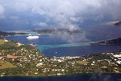
Aerial view of central Port Vila
|
||
|
||
| Location in Vanuatu | ||
| Coordinates: 17°45′S 168°18′E / 17.750°S 168.300°ECoordinates: 17°45′S 168°18′E / 17.750°S 168.300°E | ||
| Country |
|
|
| Province | Shefa Province | |
| Island | Efate | |
| Government | ||
| • Mayor | Ulrich Sumptoh | |
| Population (2009) | ||
| • Total | 44,040 | |
| Time zone | VUT (UTC+11) | |
Port Vila /ˌpɔərt ˈviːlə/ is the capital and largest city of Vanuatu and is located on the island of Efate.
Its population in the last census (2009) was 44,040, an increase of 50% on the previous census result (29,356 in 1999). In 2009, the population of Port Vila formed 18.8% of the country's population, and 66.9% of the population of Efate.
Situated on the south coast of the island of Efate, in Shefa Province, Port Vila is the economic and commercial centre of Vanuatu. The current mayor is Ulrich Sumptoh, of the Union of Moderate Parties, elected in January 2014; his deputy is Leimara Malachi, of the Vanua'aku Pati.
On March 13, 2015, Port Vila bore extensive damage from Cyclone Pam.
Locally the town is most commonly referred to simply as "Vila" (with a long i sound, not like English "villa").
The name of the area is Efil in the native South Efate language and Ifira in neighbouring Mele-Fila language. Vila is a variant of these names. Today, Ifira refers to the small island in Vila harbour where many of the area's traditional landowners reside.
The area occupied by Port Vila has been inhabited by Melanesian people for thousands of years. In Autumn of 2004, an archaeological expedition known as Teouma discovered a burial site of 25 tombs containing three dozen skeletons of members of the Lapita culture. Pieces of ceramics found at the site were dated to the 13th century BC.
In May 1606, the first Europeans arrived at the island, led by the Portuguese explorers Pedro Fernandes de Queirós and Luis Vaz de Torres. In the 19th century when the islands were known as the New Hebrides, the British possessed economic control of the zone, though by the end of 1880, the economic balance began to favour the French; this transition can be seen in its nickel mines of New Caledonia and plantations. French citizen Ferdinand Chevillard began buying and clearing land around Port Vila to be converted into the largest French plantation on the island. Instead, it was converted into the municipality of Franceville, which declared independence on August 9, 1889, though this only lasted until June of the following year.
...
Wikipedia


