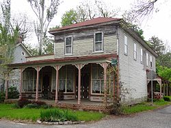
Port Republic, New Jersey
| Port Republic, New Jersey | |
|---|---|
| City | |
| City of Port Republic | |

|
|
 Map of Port Republic in Atlantic County. Inset: Location of Atlantic County in the State of New Jersey. |
|
 Census Bureau map of Port Republic, New Jersey |
|
| Coordinates: 39°32′04″N 74°28′37″W / 39.534381°N 74.476981°WCoordinates: 39°32′04″N 74°28′37″W / 39.534381°N 74.476981°W | |
| Country | |
| State |
|
| County | Atlantic |
| Incorporated | March 1, 1905 |
| Government | |
| • Type | City |
| • Body | City Council |
| • Mayor | Gary B. Giberson (term ends December 31, 2017) |
| • Clerk | Kimberly A. Campellone |
| Area | |
| • Total | 8.583 sq mi (22.230 km2) |
| • Land | 7.482 sq mi (19.378 km2) |
| • Water | 1.101 sq mi (2.852 km2) 12.83% |
| Area rank | 226th of 566 in state 13th of 23 in county |
| Elevation | 7 ft (2 m) |
| Population (2010 Census) | |
| • Total | 1,115 |
| • Estimate (2015) | 1,100 |
| • Rank | 530th of 566 in state 21st of 23 in county |
| • Density | 149.0/sq mi (57.5/km2) |
| • Density rank | 524th of 566 in state 20th of 23 in county |
| Time zone | Eastern (EST) (UTC-5) |
| • Summer (DST) | Eastern (EDT) (UTC-4) |
| ZIP code | 08241 |
| Area code | 609 exchanges: 404, 652, 748 |
| FIPS code | 3400160600 |
| GNIS feature ID | 0885360 |
| Website | www |
Port Republic is a city on the Mullica River, located in Atlantic County, New Jersey, United States. As of the 2010 United States Census, the city had a total population of 1,115, reflecting an increase of 78 (+7.5%) from the 1,037 counted in the 2000 Census, which had in turn increased by 45 (+4.5%) from the 992 counted in the 1990 Census.
It is a dry town, where alcohol cannot be sold.
Port Republic was settled as early as 1637, but a charter was not applied for until the founders Evi Smith, Hugh McCullum, and Richard Wescoat applied for a Royal charter to build a dam, sawmill, and gristmill on their land along Nacote Creek.
In its early days, Port Republic was known as Wrangleboro. During the American Revolutionary War, Port Republic provided refuge to the residents of the nearby community of Chestnut Neck when the British Army, arriving by ship, sacked their town on October 6, 1778. It had been used as a base by privateers who were capturing goods intended for British forces. Among the refugees was Daniel Mathis, a tavernkeeper who built the Franklin Inn in Port Republic, which is used as a private house today. Some of the British ships were trapped in the creek by the ebb tides. The General Lafayette Chapter of the Daughters of the American Revolution erected a monument on October 6, 1911, to mark the site of the Battle of Chestnut Neck. A Continental Army soldier at the top of the 50-foot (15 m) monument faces the river, "guarding the shore" against the approaching enemy.
In 1842, an effort was made to rename the area from Wrangleborough to Unionville, with a post office to be established under that name. As another Unionville existed in the state, the name "Port Republic" was chosen.
...
Wikipedia
