Port Perry
| Port Perry | |
|---|---|

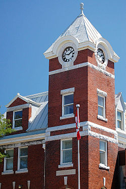
Historic Post Office in Downtown Port Perry
|
|
| Coordinates: 44°6′N 78°57′W / 44.100°N 78.950°WCoordinates: 44°6′N 78°57′W / 44.100°N 78.950°W | |
| Country | Canada |
| Province | Ontario |
| Regional municipality | Durham |
| Township | Scugog |
| Settled | 1821 |
| Incorporated (village) | 1871 |
| Population (2011) | |
| • Total | 8,981 |
| • Density | 1,207.2/km2 (3,127/sq mi) |
| Time zone | EST (UTC−5) |
| • Summer (DST) | EDT (UTC−4) |
| Forward sortation area | L9L |
| Area code(s) | 905 and 289 |
| NTS Map | 031D02 |
| GNBC Code | FCIAS |
Port Perry is a community located in Scugog Township in Durham Regional Municipality, Ontario, Canada. The town is located northeast of Toronto and just north of Oshawa. Due to its location in the Greater Toronto Area, many residents will commute to Toronto for work on a daily basis. Port Perry has a population of 8,891 as of 2011.
Port Perry serves as the administrative and commercial centre for the Township of Scugog. The town is home to a 24-bed hospital, Scugog Township's municipal offices and many retail establishments. Port Perry serves as a hub for many small communities in the Scugog area, such as Greenbank, Raglan, Caesarea, Blackstock and Nestleton/Nestleton Station. The Great Blue Heron Charitable Casino is a major employer. Located at the basin of the Trent-Severn Waterways is Lake Scugog, one of Ontario's largest man-made lakes.
The area around Port Perry was first surveyed as part of Reach Township by Major S. Wilmot in 1809. The first settler in the area was Reuben Crandell, a United Empire Loyalist who built a homestead with his wife in May 1821. Their original home is still in use and can be seen on King Street between Prince Albert and Manchester. In November 1821, Lucy Ann Crandell became the first child of European descent born in the area. In 1831, Crandell and his family moved to a homestead at what became Crandell's Corners (later called Borelia). It had its own Post Office, near the present-day junction of Queen Street and Highway 7A.
Settler Peter Perry laid out village lots on the shore of Lake Scugog in 1848 on the site of a former native village known as Scugog Village. The townsite was named Port Perry in 1852 and its first Postmaster was Joseph Bigelow. It was incorporated as a village in 1871. At the time there was an intense rivalry between Port Perry and two nearby towns, Prince Albert and Manchester. Expecting great things for "his" town, Peter Perry predicted that goats would eat grass off of Prince Albert's main street.
At the time, Prince Albert sat astride a planked toll road running south to Whitby. Grain and lumber from areas throughout the area south-east of Lake Simcoe fed through Prince Albert, which was a major grain trading area. Perry and others in Port Perry felt a railway was a much better option, and Perry's prediction would eventually come true.
...
Wikipedia
