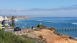
Port Noarlunga
|
Port Noarlunga Adelaide, South Australia |
|||||||||||||
|---|---|---|---|---|---|---|---|---|---|---|---|---|---|

Port Noarlunga jetty and reef, viewed from Witton Bluff
|
|||||||||||||
| Coordinates | 35°08′51″S 138°28′36″E / 35.147550°S 138.476570°ECoordinates: 35°08′51″S 138°28′36″E / 35.147550°S 138.476570°E | ||||||||||||
| Population | 2,632 (2011 census) | ||||||||||||
| Established | 1856 | ||||||||||||
| Postcode(s) | 5167 | ||||||||||||
| Location | 27 km (17 mi) south of Adelaide | ||||||||||||
| LGA(s) | City of Onkaparinga | ||||||||||||
| Region | Southern Adelaide | ||||||||||||
| County | Adelaide | ||||||||||||
| State electorate(s) | Kaurna | ||||||||||||
| Federal Division(s) | Kingston | ||||||||||||
|
|||||||||||||
|
|||||||||||||
| Footnotes | Coordinates Location Climate Adjoining suburbs |
||||||||||||
Port Noarlunga is a suburb in the City of Onkaparinga, South Australia. It is a small sea-side suburb, population 2,632, about 30 kilometres (19 mi) to the south of the Adelaide city centre and was originally created as a sea port. This area is now popular as a holiday destination or for permanent residents wishing to commute to Adelaide or work locally. There is a jetty that connects to a 1.6 kilometres (0.99 mi) long natural reef that is exposed at low tide. The beach is large and very long and has reasonable surfing in the South Port area whose name is taken from its location - 'South of the Port'.
The suburb is bounded to the south by the Onkaparinga River, including a tidal estuary. It is bounded to the west by the coastline with Gulf St Vincent, by Christies Beach to the north and by Noarlunga Centre and Noarlunga Downs to the east.
In pre-European times, this area along with most of the Adelaide plains was inhabited by the Kaurna tribe.
The first record of the area was provided by Captain Collet Barker who explored the Onkaparinga River on 15 April 1831 in his search for a Gulf outlet from Lake Alexandrina. In early 1837, while camped by the Sturt River near Marion, South Australia's only two horses slipped their tether ropes during the night and the overseer of stock, C.W. Stuart led an expedition to recover them. Taking a botanist to record the plants encountered, the expedition searched much of present-day Noarlunga before finding the horses near the Onkaparinga River. The men being on foot were however, unable to capture them. In June 1837, Colonel William Light led an overland expedition to arrest whalers who had been abducting native women at Encounter Bay, 100 km south of Adelaide. Cresting Tapleys Hill they named the valley Morphett Vale after expedition member John Morphett. They reached the southern end of the Mount Lofty Ranges before impenetrable scrub forced them to return to Adelaide. The following year, John McLaren of the Survey Dept. divided the area south of Adelaide into three districts (B.C and D) based on the reports made by the Stuart and Light expeditions. B and C districts, the present Noarlunga District, was opened to public selection in February 1839 and by 1841 the population was estimated to be about 150. The government town of Port Noarlunga was surveyed and offered for sale on 14 April 1859.
...
Wikipedia

