Port Hedland
|
Port Hedland Western Australia |
|||||||
|---|---|---|---|---|---|---|---|

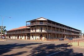
Esplanade Hotel, Port Hedland, April 2012.
|
|||||||
| Coordinates | 20°18′36″S 118°36′04″E / 20.31000°S 118.60111°ECoordinates: 20°18′36″S 118°36′04″E / 20.31000°S 118.60111°E | ||||||
| Population | 15,191 (2015) | ||||||
| Established | 1880s | ||||||
| Postcode(s) | 6721 | ||||||
| Elevation | 6 m (20 ft) | ||||||
| Time zone | AWST (UTC+8) | ||||||
| Location |
|
||||||
| LGA(s) | Town of Port Hedland | ||||||
| State electorate(s) | Pilbara | ||||||
| Federal Division(s) | Durack | ||||||
|
|||||||
Port Hedland (Kariyarra: Marapikurrinya) is the second largest town in the Pilbara region of Western Australia, with an estimated urban population of 15,191, including the satellite town of South Hedland, 18 km away. It is also the site of the highest tonnage port in Australia.
Port Hedland has a natural deep anchorage harbour which, as well as being the main fuel and container receival point for the region, was seen as perfect for shipment of the iron ore being mined in the ranges located inland from the town. The ore is moved by railway from four major iron ore deposits to the east and south of Port Hedland area. In August 2010 the port exported 13.6 million tonnes of iron ore. In March 2016 a new monthly record of 39.6m tons was set.
Other major resource activities supported by the town include the offshore natural gas fields, salt, manganese, and livestock. Grazing of cattle and sheep was formerly a major revenue earner for the region but this has slowly declined. Port Hedland was also formerly the terminus for the WAGR Marble Bar Railway which serviced the gold mining area of Marble Bar. Located between Port Hedland and South Hedland are the large salt hills of Dampier Salt, a subsidiary of Rio Tinto. These large mounds have almost become a tourist attraction in their own right.
Port Hedland is known by the Indigenous Kariyarra and Nyamal people as Marapikurrinya, which either means "place of good water" (as told by a Nyamal language speaker) and makes reference to the three reliable fresh water soaks that can still be seen in and around the town, or as the town council's website says "refers to the hand like formation of the tidal creeks coming off the harbour (marra - hand, pikurri - pointing straight and nya - a place name marker)". According to Dreamtime legend there was a huge blind water snake living in the landlocked area of water known as Jalkawarrinya. This landlocked area is now the turning basin for the ships that enter the port and as the story goes, "the coming of the big ships meant it was unable to stay".
...
Wikipedia

