Port Elgin, New Brunswick
| Port Elgin | |
|---|---|
| Village | |

Port Elgin in 2007
|
|
| Motto: "Your Port of Call" | |
| Location of Port Elgin within New Brunswick. | |
| Coordinates: 46°04′59″N 64°09′29″W / 46.08306°N 64.15806°WCoordinates: 46°04′59″N 64°09′29″W / 46.08306°N 64.15806°W | |
| Country | Canada |
| Province | New Brunswick |
| County | Westmorland |
| Established | 1690 |
| Government | |
| • Mayor | Judy McCray |
| • MPs | MLA |
| Area | |
| • Total | 18.55 km2 (7.162 sq mi) |
| Elevation | 2 m (5 ft) |
| Highest elevation | 4 m (14 ft) |
| Lowest elevation | 0 m (0 ft) |
| Population (2011) | |
| • Total | 418 |
| • Density | 24.25/km2 (62.8/sq mi) |
| Demonym(s) | Portelginian |
| Time zone | AST (UTC-4) |
| • Summer (DST) | ADT (UTC-3) |
| Postal code(s) | E4M |
| Area code(s) | 506 |
| Access Routes |
|
| Dwellings | 229 |
| Website | www |

Fort Monckton Lighthouse in 2006
|
|
|
New Brunswick
|
|
| Location | Gaspereaux Point Port Elgin New Brunswick Canada |
|---|---|
| Coordinates | 46°2′35.64″N 64°4′14.74″W / 46.0432333°N 64.0707611°W |
| Year first constructed | 1908 (first) |
| Year first lit | 1971 (current) |
| Deactivated | 1971 (first) |
| Foundation | concrete basement |
| Construction | fiberglass tower |
| Tower shape | cylindrical tower with light |
| Markings / pattern | red tower with a central white band |
| Height | 7 metres (23 ft) |
| Focal height | 10 metres (33 ft) |
| Light source | solar power |
| Range | 7 nautical miles (13 km; 8.1 mi) |
| Characteristic | Fl W 3s. (seasonal) |
| Admiralty number | H1304 |
| CHS number | CCG 1086 |
| NGA number | 7844 |
| ARLHS number | CAN-183 |
| Managing agent | Parks Canada (Fort Gaspereaux National Historic Site) |
Port Elgin is a Canadian village in Westmorland County, New Brunswick. It is located near the Nova Scotia border at the mouth of the Gaspereaux River where it empties into Baie Verte of the Northumberland Strait.
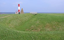
The village was founded by Acadians in 1690, but abandoned after the Expulsion of the Acadians in 1755. The earthworks of Fort Gaspareaux, a French military fortification from the Seven Years' War are located at the mouth of the river immediately east of the village.
Following the Seven Years' War and the American Revolutionary War, British Loyalists resettled in the area which was named Gaspareaux Town. Gaspareaux Town was renamed Port Elgin in 1847 in honour of Lord Elgin. The community was incorporated as a village in 1922, the first community in the province to do so.
Throughout the 19th century and first half of the 20th century, Port Elgin experienced modest industrialization with a handful of small factories, tanneries, and sawmills. The village also saw some shipping activity with several wharves on a sheltered harbour at the mouth of the Gaspereau River. The New Brunswick and Prince Edward Island Railway was built through the village in the early 1880s, opening on September 9, 1886 to connect the Intercolonial Railway at Sackville with the seasonal port of Cape Tormentine which supported the winter iceboat service to Prince Edward Island; in 1917 this port became a terminal for the year-round ferry service to P.E.I.
...
Wikipedia


