Port-Daniel, Quebec
| Port-Daniel–Gascons | |
|---|---|
| Municipality | |

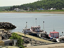
Harbour at Port-Daniel–Gascons
|
|
 Location within Le Rocher-Percé RCM. |
|
| Location in eastern Quebec. | |
| Coordinates: 48°11′N 64°58′W / 48.183°N 64.967°WCoordinates: 48°11′N 64°58′W / 48.183°N 64.967°W | |
| Country |
|
| Province |
|
| Region | Gaspésie–Îles-de-la-Madeleine |
| RCM | Le Rocher-Percé |
| Constituted | January 17, 2001 |
| Government | |
| • Mayor | Henri Grenier (2013-2017) |
| • Federal riding | Gaspésie—Îles-de-la-Madeleine |
| • Prov. riding | Bonaventure |
| Area | |
| • Total | 332.00 km2 (128.19 sq mi) |
| • Land | 302.69 km2 (116.87 sq mi) |
| Population (2011) | |
| • Total | 2,453 |
| • Density | 8.1/km2 (21/sq mi) |
| • Pop 2006-2011 |
|
| • Dwellings | 1,173 |
| Time zone | EST (UTC−5) |
| • Summer (DST) | EDT (UTC−4) |
| Postal code(s) | G0C 2N0 |
| Area code(s) | 418 and 581 |
| Highways |
|
| Website | www |
Port-Daniel–Gascons is a municipality in the Gaspésie-Îles-de-la-Madeleine region of the province of Quebec in Canada.
The municipality includes the communities of Marcil, Clemville, Port-Daniel, and Gascons. It was formed on January 17, 2001, through the merger of the Municipality of Port-Daniel and the Parish Municipality of Sainte-Germaine-de-l'Anse-aux-Gascons.
Port Daniel is no longer easily accessible by train due to track closures until local bridges are prepared although the train station is close to the city hall.
...
Wikipedia

