Porongurup National Park
|
Porongurup National Park Western Australia |
|
|---|---|
|
IUCN category II (national park)
|
|
 |
|
| Nearest town or city | Mount Barker, Western Australia, Australia |
| Coordinates | 34°40′46″S 117°52′23″E / 34.67944°S 117.87306°ECoordinates: 34°40′46″S 117°52′23″E / 34.67944°S 117.87306°E |
| Established | 1971 |
| Area | 26.21 km2 (10.1 sq mi) |
| Managing authorities | Department of Parks and Wildlife |
| Website | Porongurup National Park |
| See also | List of protected areas of Western Australia |
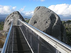
Porongurup National Park is a national park in the Great Southern region of Western Australia (Australia), 360 km southeast of Perth and 40 km from Albany.
It protects the Porongurup Range, an extremely ancient and largely levelled mountain range formed in the Precambrian over 1200 million years ago. The present range is no more than fifteen km (10 miles) from east to west and consists of granite peaks levelled into domes. The highest point in the Porongurup Range is Devils Slide at 670 metres (2,200 ft) whilst there are several other peaks above 600 metres (1,970 ft), which is about 400 metres above the surrounding plain. Indeed, for much of the Cretaceous and Paleogene the Porongurup Range was an island surrounded by the sea, with the Stirling Range forming the southern coastline.
It is believed that the Porongurup Range is a remnant of the Precambrian collision that joined Australia and Antarctica until they separated in the Paleocene. There remain major granite intrusions in what is left of what must once have been a large mountain range.
Although Aboriginal tribes had lived in the plains around the Porongurup Range for tens of thousands of years before European settlement, it is believed that they never or very rarely moved above the plains, largely because of the often inhospitable weather and the absence of useful resources in the forests of the region or on the often bare peaks.
The Porongurup Range was first sighted by Europeans passing near Albany in 1802 but farming in the surrounding districts did not start until around 1859 when vegetables were first grown on the southern slopes of the range. The giant karri and jarrah trees of the range were first harvested for timber in the 1880s and timber leases did not begin to be withdrawn until 1925 and the National Park was not gazetted officially until 1971 with an area of 1,157 ha. This has now been increased to 2,511 ha.
...
Wikipedia

