Poortvliet
| Poortvliet | |||
|---|---|---|---|
| Village | |||
|
|||
 |
|||
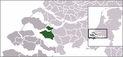
 The village centre (dark green) and the statistical district (light green) of Poortvliet in the municipality of Tholen. |
|||
| Coordinates: 51°32′40″N 4°8′39″E / 51.54444°N 4.14417°ECoordinates: 51°32′40″N 4°8′39″E / 51.54444°N 4.14417°E | |||
| Country | Netherlands | ||
| Province | Zeeland | ||
| Municipality | Tholen | ||
| Area | |||
| • Total | 31.36 km2 (12.11 sq mi) | ||
| Population (1 January 2010) | |||
| • Total | 1,706 | ||
| • Density | 54/km2 (140/sq mi) | ||
| Time zone | CET (UTC+1) | ||
| • Summer (DST) | CEST (UTC+2) | ||
Poortvliet (Zeelandic: Poôfliet, Dutch pronunciation: [ˈpoːrtflit]) is a village in the Dutch province of Zeeland. It is a part of the municipality of Tholen, and lies about 12 km northwest of Bergen op Zoom.
Poortvliet was a separate municipality until 1971, when it was merged with Tholen.
In 2001, the village of Poortvliet had 1154 inhabitants. The built-up area of the village was 0.43 km², and contained 489 residences. The statistical area "Poortvliet", which also can include the surrounding countryside, has a population of around 1720.
...
Wikipedia


